|
search place name
|
||
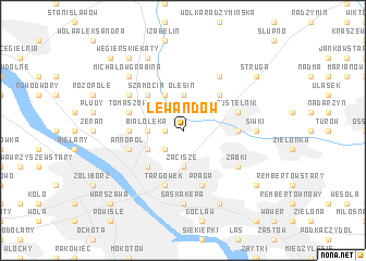
Lewandów (Poland)Lewandów is a town in Poland. An overview map of the region around Lewandów is displayed below.
regional and 3d topo map of Lewandów, Poland ::
Lewandów airports ::
The nearest airport is WAW - Warsaw Okecie, located 18.1 km south of Lewandów.
Other airports nearby include KTW - Katowice Pyrzowice (247.2 km south west), Nearby towns ::
Grodzisk (1.9km north) //
Augustów (1.9km north) //
Brzeziny (1.1km west) //
Stare Bródno (2.2km south west) //
Olesin (3.7km north) //
Augustówek (3.7km north) //
Zacisze (3.7km south) //
Białołeka (2.3km west) //
Mańki (3.9km north) //
Aleksandrów (2.9km south west) //
Kępa Tarchomińska (4.3km north east) //
Szamocin (4.3km north west) //
Nowe Bródno (4.3km south west) //
Konstantynów (3.4km west) //
Kąty Grodziskie (3.4km west) //
Drewnica (3.4km east) //
Praga (5.7km south) //
Tomaszów (3.9km north west) //
Pustelnik (3.9km north east) //
Targówek (5.7km south) //
Annopol (3.9km south west) //
Kobiałka (5.0km north west) //
Czarna Struga (6.0km north) //
Ząbki (5.0km south east) //
Siwki (4.5km east) //
Marki (4.5km east) //
Saska Kępa (7.4km south) //
Michałów Grabina (6.5km north west) //
Stanisławów (7.8km north) //
[all distances 'as the bird flies' and approximate]  Places with similar names to Lewandów, Poland ::
Disclaimer :: Information on this page comes without warranty of any kind |
||
|
Where is Lewandów? Elevation and coordinates ::
Latitude (lat): 52°19'0"N Longitude (lon): 21°4'0"E
Elevation (approx.): 81m (map arrows pan, magnifying glasses zoom) |
||
|
Visiting Lewandów? Hotel/Accommodation ::
Book a hotel in Lewandów Travel Guide ::
Buy a travel guide for Poland rental cars ::
car rental offers GPS waypoint ::
download a GPX waypoint (PoI) of Lewandów for your GPS receiver
|
||