|
search place name
|
||
Mała Huta (Poland)Mała Huta is a town in Poland. An overview map of the region around Mała Huta is displayed below.
regional and 3d topo map of Mała Huta, Poland ::
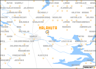
Nearby towns ::
Okuniowiec (0.0km north) //
Osinki (1.9km north) //
Krzywe (3.9km south) //
Stary Folwark (3.9km south) //
Szwajcaria (4.3km north west) //
Sobolewo (5.6km south) //
Białerogi (5.7km north) //
Jasionowo Nowe (5.7km north) //
Kolonia Jasionowo (5.7km north) //
Suwałki (3.7km south west) //
Węgielnia (6.0km north) //
Suchodoły (7.5km north) //
Nowa Wieś (4.7km north east) //
Bilwinowo (6.4km north east) //
Prudziszki (6.4km north west) //
Lipniak (5.7km north east) //
Leszczewek (5.7km south east) //
Leszczewo (5.7km south east) //
Polule (7.1km north east) //
Dubowo (8.6km south west) //
[all distances 'as the bird flies' and approximate] 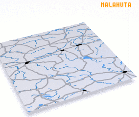 Places with similar names to Mała Huta, Poland ::
Disclaimer :: Information on this page comes without warranty of any kind |
||
|
Where is Mała Huta? Elevation and coordinates ::
Latitude (lat): 54°7'0"N Longitude (lon): 22°59'0"E
Elevation (approx.): 154m (map arrows pan, magnifying glasses zoom) |
||
|
Visiting Mała Huta? Hotel/Accommodation ::
Book a hotel in Mała Huta Travel Guide ::
Buy a travel guide for Poland rental cars ::
car rental offers GPS waypoint ::
download a GPX waypoint (PoI) of Mała Huta for your GPS receiver
|
||