|
search place name
|
||
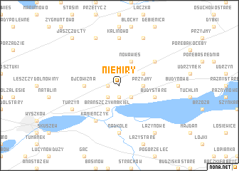
Niemiry (Poland)Niemiry is a town in Poland. An overview map of the region around Niemiry is displayed below.
regional and 3d topo map of Niemiry, Poland ::
Niemiry airports ::
The nearest airport is WAW - Warsaw Okecie, located 68.3 km south west of Niemiry.
Nearby towns ::
Trzcianka (1.1km west) //
Brańszczyk Nowy (1.9km south) //
Brańszczyk Bieliny (2.2km south west) //
Brańszczyk (2.2km south east) //
Przyjmy (2.2km east) //
Brańszczyk Nowy (2.2km east) //
Brańszczyk Nakieł (3.9km south) //
Nowa Wieś (3.9km north) //
Knurowiec (2.9km north east) //
Ojcowizna (3.4km west) //
Budy Stare (3.8km south east) //
Kamieńczyk (6.0km south) //
Budykierz (5.0km north east) //
Kalinowo (7.4km north) //
Nadkole (7.4km south) //
Turzyn (5.8km south west) //
Dalekie (7.7km north) //
Białe Błoto Kobyle (7.7km north) //
Łazy Nowe (8.1km south east) //
Jaszczułty (8.7km north west) //
[all distances 'as the bird flies' and approximate] 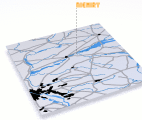 Places with similar names to Niemiry, Poland ::
Disclaimer :: Information on this page comes without warranty of any kind |
||
|
Where is Niemiry? Elevation and coordinates ::
Latitude (lat): 52°39'0"N Longitude (lon): 21°35'0"E
Elevation (approx.): 94m (map arrows pan, magnifying glasses zoom) |
||
|
Visiting Niemiry? Hotel/Accommodation ::
Book a hotel in Niemiry Travel Guide ::
Buy a travel guide for Poland rental cars ::
car rental offers GPS waypoint ::
download a GPX waypoint (PoI) of Niemiry for your GPS receiver
|
||