|
search place name
|
||
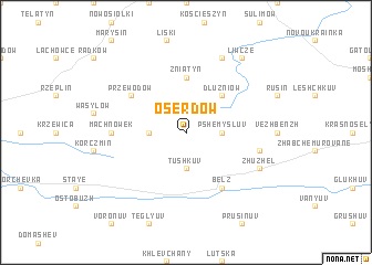
Oserdów (Poland)Oserdów is a town in Poland. An overview map of the region around Oserdów is displayed below.
regional and 3d topo map of Oserdów, Poland ::
Oserdów airports ::
The nearest airport is LWO - Lvov Lviv Intl, located 69.1 km south of Oserdów.
Other airports nearby include RZE - Rzeszow Jasionka (144.6 km west), Nearby towns ::
Chłopiatyn (1.9km north) //
Myców (2.2km north east) //
Budzynin (2.4km west) //
Tushkuv (3.7km south) //
Pshemysluv (2.4km east) //
Dłużniów (4.4km north east) //
Żniatyn (5.6km north) //
Przewodów (5.1km north west) //
Belz (6.0km south east) //
Machnówek (4.7km west) //
Tsebluv (5.1km east) //
Zhuzhelʼ (6.0km south east) //
Hulcze (7.8km north) //
Chochłów (7.8km north) //
Liwcze (8.2km north east) //
[all distances 'as the bird flies' and approximate] 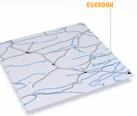 Places with similar names to Oserdów, Poland ::
// Ouaouizerht (MA)
// Ouaouizerht (MA)
// Ouaouizert (MA)
// Ousroutou (MA)
// Ouizert (MA)
// Ozourt (FR)
// Ouaouizarht (MA)
// Ouaouzert (MA)
// Ouaouzrout (MA)
// Ouizert (DZ)
Disclaimer :: Information on this page comes without warranty of any kind |
||
|
Where is Oserdów? Elevation and coordinates ::
Latitude (lat): 50°26'0"N Longitude (lon): 23°59'0"E
Elevation (approx.): 256m (map arrows pan, magnifying glasses zoom) |
||
|
Visiting Oserdów? Hotel/Accommodation ::
Book a hotel in Oserdów Travel Guide ::
Buy a travel guide for Poland rental cars ::
car rental offers GPS waypoint ::
download a GPX waypoint (PoI) of Oserdów for your GPS receiver
|
||