|
search place name
|
||
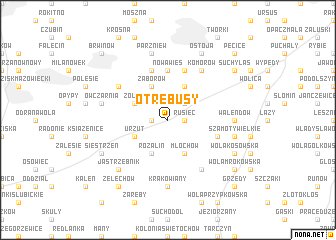
Otrebusy (Poland)Otrebusy is a town in Poland. An overview map of the region around Otrebusy is displayed below.
regional and 3d topo map of Otrebusy, Poland ::
Otrebusy airports ::
The nearest airport is WAW - Warsaw Okecie, located 15.6 km north east of Otrebusy.
Other airports nearby include KTW - Katowice Pyrzowice (214.9 km south west), RZE - Rzeszow Jasionka (236.0 km south), Nearby towns ::
Stara Wieś (1.1km west) //
Rusiec (1.1km east) //
Nadarzyn (2.2km north east) //
Urzut (2.9km south west) //
Rozalin (3.9km south) //
Żółwin (2.9km north west) //
Młochów (3.9km south) //
Zaborów (3.9km north) //
Strzeniówka (3.9km north) //
Nowa Wieś (5.6km north) //
Kanie (5.7km north) //
Szamoty Małe (3.9km south east) //
Granica (5.7km north) //
Parole (6.0km south) //
Komorów (6.0km north) //
Podkowa Leśna (5.0km north west) //
Krakowiany (7.4km south) //
Walendów (4.6km east) //
Owczarnia (4.9km west) //
Parzniew (7.5km north) //
Szamoty (4.9km east) //
Szamoty Wielkie (4.9km east) //
Jastrzębnik (6.5km south west) //
Siestrzeń (5.9km south west) //
Wola Kosowska (5.9km south east) //
Miasto Ogród Komorów (7.8km north) //
Ostoja (7.8km north) //
Żelechów (8.2km south west) //
Suchy Las (7.2km north east) //
[all distances 'as the bird flies' and approximate] 
Disclaimer :: Information on this page comes without warranty of any kind |
||
|
Where is Otrebusy? Elevation and coordinates ::
Latitude (lat): 52°5'0"N Longitude (lon): 20°47'0"E
Elevation (approx.): 116m (map arrows pan, magnifying glasses zoom) |
||
|
Visiting Otrebusy? Hotel/Accommodation ::
Book a hotel in Otrebusy Travel Guide ::
Buy a travel guide for Poland rental cars ::
car rental offers GPS waypoint ::
download a GPX waypoint (PoI) of Otrebusy for your GPS receiver
|
||