|
search place name
|
||
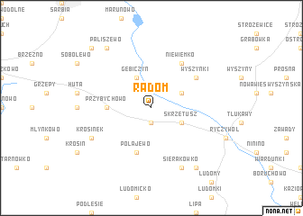
Radom (Poland)Radom is a town in Poland. An overview map of the region around Radom is displayed below.
regional and 3d topo map of Radom, Poland ::
Radom airports ::
The nearest airport is POZ - Poznan Lawica, located 48.0 km south of Radom.
Other airports nearby include IEG - Zielona Gora Babimost (102.2 km south west), SZZ - Szczechin Goleniow (148.1 km north west), OSP - Slupsk Redzikowo (182.8 km north), WRO - Wroclaw Strachowice (194.6 km south), Nearby towns ::
Piotrowo (1.9km south) //
Gębiczyn (3.9km north) //
Skrzetusz (2.9km south east) //
Połajewice (2.9km north east) //
Przybychowo (3.4km west) //
Połajewo (5.7km south) //
Niewiemko (6.0km north) //
Wyszynki (5.0km north east) //
Sierakówko (7.7km south) //
Krosinek (5.8km south west) //
Paliszewo (8.1km north west) //
Budziska (8.1km south east) //
Gębice (8.7km north west) //
[all distances 'as the bird flies' and approximate] 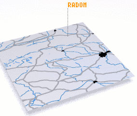 Places with similar names to Radom, Poland ::
// Reteïm (MA)
// Rio do Meio (BR)
// Rio do Meio (BR)
// Rātma (MM)
// Ridam (MM)
// Radium (US)
// Rittham (AT)
// Radom (US)
// Radium (US)
// Rottum (DE)
Disclaimer :: Information on this page comes without warranty of any kind |
||
|
Where is Radom? Elevation and coordinates ::
Latitude (lat): 52°51'0"N Longitude (lon): 16°45'0"E
Elevation (approx.): 81m (map arrows pan, magnifying glasses zoom) |
||
|
Visiting Radom? Hotel/Accommodation ::
Book a hotel in Radom Travel Guide ::
Buy a travel guide for Poland rental cars ::
car rental offers GPS waypoint ::
download a GPX waypoint (PoI) of Radom for your GPS receiver
|
||