|
search place name
|
||
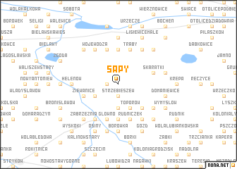
Sapy (Poland)Sapy is a town in Poland. An overview map of the region around Sapy is displayed below.
regional and 3d topo map of Sapy, Poland ::
Sapy airports ::
The nearest airport is WAW - Warsaw Okecie, located 85.1 km east of Sapy.
Other airports nearby include KTW - Katowice Pyrzowice (177.9 km south), KRK - Krakow Balice (215.7 km south), Nearby towns ::
Władysławów (1.1km west) //
Strzebieszew (1.9km south) //
Kamień Paleniec (3.7km south) //
Wola Zbrożkowa (2.9km south west) //
Toporów (3.9km south) //
Stroniewice (4.4km south east) //
Chruślin (5.6km north) //
Paleniec (5.6km south) //
Skaratki (3.9km north east) //
Trąby (5.7km north) //
Piotrowice (5.7km north) //
Ziewanice (3.9km south west) //
Rudniczek (5.7km south) //
Głowno (5.7km south) //
Wojewodza (6.0km north) //
Lisiewice (6.0km north) //
Różyce (6.0km south) //
Ostrołęka Małszyce (6.0km south) //
Warchałów Nowy (6.0km south) //
Cichorajka (6.0km south) //
Ostrołęka Stroniewice (5.0km south east) //
Kolonia Wymysłów (5.0km south east) //
Chruślin Kościelny (7.4km north) //
Helenów (4.6km west) //
Borówka (7.4km south) //
Rogoźno (4.9km east) //
Huta Józefów (7.5km south) //
Domaniewice (4.9km east) //
Lisiewice Wielkie (6.5km north east) //
[all distances 'as the bird flies' and approximate]  Places with similar names to Sapy, Poland ::
Disclaimer :: Information on this page comes without warranty of any kind |
||
|
Where is Sapy? Elevation and coordinates ::
Latitude (lat): 52°1'0"N Longitude (lon): 19°45'0"E
Elevation (approx.): 116m (map arrows pan, magnifying glasses zoom) |
||
|
Visiting Sapy? Hotel/Accommodation ::
Book a hotel in Sapy Travel Guide ::
Buy a travel guide for Poland rental cars ::
car rental offers GPS waypoint ::
download a GPX waypoint (PoI) of Sapy for your GPS receiver
|
||