|
search place name
|
||
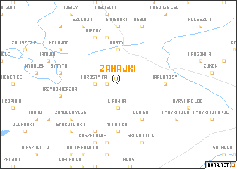
Zahajki (Poland)Zahajki is a town in Poland. An overview map of the region around Zahajki is displayed below.
regional and 3d topo map of Zahajki, Poland ::
Zahajki airports ::
The nearest airport is RZE - Rzeszow Jasionka, located 188.1 km south west of Zahajki.
Other airports nearby include LWO - Lvov Lviv Intl (204.4 km south), Nearby towns ::
Ignaców (1.2km west) //
Horostyta (2.3km west) //
Lipówka (3.7km south) //
Mosty (5.6km north) //
Lubień (6.0km south east) //
Marianka (7.4km south) //
Kaplonosy (4.6km east) //
Bojary (7.5km north) //
Antopol (7.8km north) //
Marianka Nowa (7.8km south) //
Piechy (7.8km north) //
Zamołodycze (7.2km south west) //
Smokotówka (8.7km south west) //
Marianka Stara (8.7km south west) //
[all distances 'as the bird flies' and approximate] 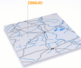 Places with similar names to Zahajki, Poland ::
// Zahajki (PL)
// Zhaijiaqiao (CN)
// Zhaojiagou (CN)
// Zhaojiagou (CN)
// Zhaojiagou (CN)
// Zhaojiagou (CN)
// Zhaojiagou (CN)
// Zhaojiaqiao (CN)
// Zhoujiagou (CN)
// Zhoujiagou (CN)
Disclaimer :: Information on this page comes without warranty of any kind |
||
|
Where is Zahajki? Elevation and coordinates ::
Latitude (lat): 51°36'0"N Longitude (lon): 23°17'0"E
Elevation (approx.): 159m (map arrows pan, magnifying glasses zoom) |
||
|
Visiting Zahajki? Hotel/Accommodation ::
Book a hotel in Zahajki Travel Guide ::
Buy a travel guide for Poland rental cars ::
car rental offers GPS waypoint ::
download a GPX waypoint (PoI) of Zahajki for your GPS receiver
|
||