|
search place name
|
||
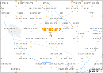
Bánmajor (Zala, Hungary)Bánmajor is a town in the Zala region of Hungary. An overview map of the region around Bánmajor is displayed below.
regional and 3d topo map of Bánmajor, Hungary ::
Bánmajor airports ::
The nearest airport is VIE - Vienna Schwechat, located 100.3 km north of Bánmajor.
Other airports nearby include GRZ - Graz (102.6 km west), BTS - Bratislava M R Stefanik (111.6 km north), MBX - Maribor (115.3 km south west), ZAG - Zagreb (172.0 km south), Nearby towns ::
Bárdos (1.9km south) //
Vép (2.2km north west) //
Bozzai (2.2km south east) //
Tanakajd (2.2km south west) //
Sándorháza (3.7km north) //
Lipárt (3.7km south) //
Csókakőmajor (3.1km north east) //
Kenéz (3.1km south east) //
Vasszécseny (3.9km south) //
Táplánszentkereszt (4.2km south west) //
Nemesbőd (5.7km north) //
Emiliamajor (5.7km north) //
Porpác (5.3km north east) //
Lajostelep (7.5km north) //
Ferencmajor (5.4km west) //
Bogátimajor (5.4km west) //
Nemeskolta (7.5km south) //
Perecmajor (6.7km north west) //
Vát (7.8km north) //
Bögötmajor (6.3km north east) //
Ferdinándmajor (6.3km south west) //
Vassurány (8.3km north west) //
Csempeszkopács (8.3km south east) //
[all distances 'as the bird flies' and approximate] 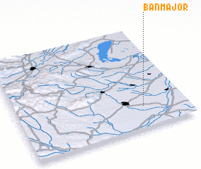 Places with similar names to Bánmajor, Hungary :: Disclaimer :: Information on this page comes without warranty of any kind |
||
|
Where is Bánmajor? Elevation and coordinates ::
Latitude (lat): 47°13'0"N Longitude (lon): 16°45'0"E
Elevation (approx.): 186m (map arrows pan, magnifying glasses zoom) |
||
|
Visiting Bánmajor? Hotel/Accommodation ::
Book a hotel in Bánmajor Travel Guide ::
Buy a travel guide for Hungary rental cars ::
car rental offers GPS waypoint ::
download a GPX waypoint (PoI) of Bánmajor for your GPS receiver
|
||