|
search place name
|
||
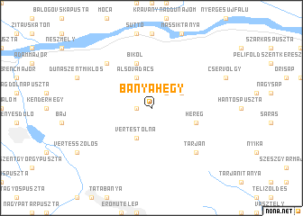
Bányahegy (Komárom-Esztergom, Hungary)Bányahegy is a town in the Komárom-Esztergom region of Hungary. An overview map of the region around Bányahegy is displayed below.
regional and 3d topo map of Bányahegy, Hungary ::
Bányahegy airports ::
The nearest airport is BUD - Budapest Ferihegy, located 64.6 km south east of Bányahegy.
Other airports nearby include BTS - Bratislava M R Stefanik (109.2 km north west), PZY - Piestany (116.7 km north west), SLD - Sliac (118.9 km north east), VIE - Vienna Schwechat (150.2 km west), Nearby towns ::
Tardosbánya (1.2km west) //
Gerecse (2.2km north east) //
Pusztamarót (3.1km north east) //
Alsóvadács (3.9km north) //
Vértestolna (3.9km south) //
Bikol (5.7km north) //
Héreg (4.2km south east) //
Tarján (6.7km south east) //
Gombáspuszta (6.7km north west) //
[all distances 'as the bird flies' and approximate] 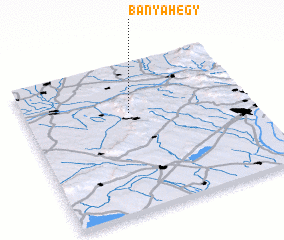
Disclaimer :: Information on this page comes without warranty of any kind |
||
|
Where is Bányahegy? Elevation and coordinates ::
Latitude (lat): 47°40'0"N Longitude (lon): 18°28'0"E
Elevation (approx.): 420m (map arrows pan, magnifying glasses zoom) |
||
|
Visiting Bányahegy? Hotel/Accommodation ::
Book a hotel in Bányahegy Travel Guide ::
Buy a travel guide for Hungary rental cars ::
car rental offers GPS waypoint ::
download a GPX waypoint (PoI) of Bányahegy for your GPS receiver
|
||