|
search place name
|
||
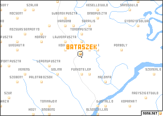
Bátaszék (Tolna, Hungary)Bátaszék is a town in the Tolna region of Hungary. An overview map of the region around Bátaszék is displayed below.
regional and 3d topo map of Bátaszék, Hungary ::
Bátaszék airports ::
The nearest airport is OSI - Osijek, located 80.3 km south of Bátaszék.
Other airports nearby include BUD - Budapest Ferihegy (144.9 km north), BEG - Beograd (195.4 km south east), BTS - Bratislava M R Stefanik (249.1 km north west), Nearby towns ::
Alsónyék (1.9km north) //
Nyékipuszta (2.3km north east) //
Furkótelep (3.7km south) //
Betekintspuszta (3.7km north) //
Furkópuszta (3.9km south) //
Kövesd (3.2km north west) //
Csikómajor (3.2km north east) //
Lajvérpuszta (4.5km north west) //
Tomorpuszta (5.6km north) //
Dolina (5.3km south west) //
Leperdpuszta (5.5km west) //
Óberekpuszta (7.5km north) //
Sárpilis (7.5km north) //
Kispilis (7.5km north) //
Malomfa (6.8km south east) //
Báta (6.8km south east) //
Várdomb (7.8km north) //
Alsónána (9.0km north west) //
[all distances 'as the bird flies' and approximate]  Places with similar names to Bátaszék, Hungary ::
Disclaimer :: Information on this page comes without warranty of any kind |
||
|
Where is Bátaszék? Elevation and coordinates ::
Latitude (lat): 46°11'0"N Longitude (lon): 18°44'0"E
Elevation (approx.): 84m (map arrows pan, magnifying glasses zoom) |
||
|
Visiting Bátaszék? Hotel/Accommodation ::
Book a hotel in Bátaszék Travel Guide ::
Buy a travel guide for Hungary rental cars ::
car rental offers GPS waypoint ::
download a GPX waypoint (PoI) of Bátaszék for your GPS receiver
|
||