|
search place name
|
||
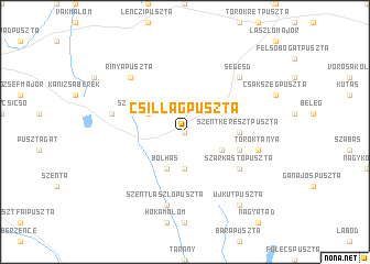
Csillagpuszta (Somogy, Hungary)Csillagpuszta is a town in the Somogy region of Hungary. An overview map of the region around Csillagpuszta is displayed below.
regional and 3d topo map of Csillagpuszta, Hungary ::
Csillagpuszta airports ::
The nearest airport is ZAG - Zagreb, located 113.7 km south west of Csillagpuszta.
Other airports nearby include MBX - Maribor (125.7 km west), OSI - Osijek (149.7 km south east), GRZ - Graz (161.8 km north west), BUD - Budapest Ferihegy (195.5 km north east), Nearby towns ::
Somogyszob (0.0km north) //
Nagybarátipuszta (3.7km south) //
Ötvös (3.2km south east) //
Bolhás (3.9km south) //
Szomorúpuszta (3.2km north west) //
Szentkeresztpuszta (3.8km east) //
Petenyepuszta (4.3km south east) //
Szarkástópuszta (5.3km south east) //
Töröktanya (5.4km east) //
Kaszópuszta (5.4km west) //
Szentlászlópuszta (7.5km south) //
Bagolai Erdősház (6.8km north east) //
Rinyapuszta (6.8km north west) //
Segesd (6.8km north east) //
Jánosmajor (8.4km south east) //
Halastópuszta (8.4km south east) //
Újkútpuszta (8.4km south east) //
[all distances 'as the bird flies' and approximate]  Places with similar names to Csillagpuszta, Hungary ::
Disclaimer :: Information on this page comes without warranty of any kind |
||
|
Where is Csillagpuszta? Elevation and coordinates ::
Latitude (lat): 46°18'0"N Longitude (lon): 17°18'0"E
Elevation (approx.): 152m (map arrows pan, magnifying glasses zoom) |
||
|
Visiting Csillagpuszta? Hotel/Accommodation ::
Book a hotel in Csillagpuszta Travel Guide ::
Buy a travel guide for Hungary rental cars ::
car rental offers GPS waypoint ::
download a GPX waypoint (PoI) of Csillagpuszta for your GPS receiver
|
||