|
search place name
|
||
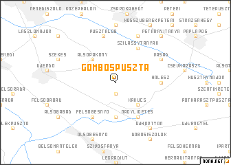
Gombospuszta (Pest, Hungary)Gombospuszta is a town in the Pest region of Hungary. An overview map of the region around Gombospuszta is displayed below.
regional and 3d topo map of Gombospuszta, Hungary ::
Gombospuszta airports ::
The nearest airport is BUD - Budapest Ferihegy, located 18.1 km north of Gombospuszta.
Other airports nearby include SLD - Sliac (151.3 km north), PZY - Piestany (186.8 km north west), ARW - Arad (192.0 km south east), OSI - Osijek (206.3 km south), Nearby towns ::
Bucka (1.9km south) //
Vagyonváltságföld (1.9km south) //
Inárcs (1.9km south) //
Offnertelep (1.9km south) //
Kecskemétitanya (1.9km south) //
Pataktanya (1.9km south) //
Alsópakony (4.5km north west) //
Kakucs (4.5km south east) //
Csikóspuszta (5.6km south) //
Felsőbesnyő (6.1km south west) //
Szilassytanyák (6.1km north east) //
Nagyligetes (6.1km south east) //
Halesz (5.0km east) //
Pusztalöb (7.5km north) //
Vasad (6.2km north east) //
Halmosháza (7.8km north) //
Újhartyán (8.3km south east) //
Petrányitanya (9.0km north east) //
[all distances 'as the bird flies' and approximate] 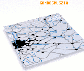 Places with similar names to Gombospuszta, Hungary ::
Disclaimer :: Information on this page comes without warranty of any kind |
||
|
Where is Gombospuszta? Elevation and coordinates ::
Latitude (lat): 47°17'0"N Longitude (lon): 19°20'0"E
Elevation (approx.): 123m (map arrows pan, magnifying glasses zoom) |
||
|
Visiting Gombospuszta? Hotel/Accommodation ::
Book a hotel in Gombospuszta Travel Guide ::
Buy a travel guide for Hungary rental cars ::
car rental offers GPS waypoint ::
download a GPX waypoint (PoI) of Gombospuszta for your GPS receiver
|
||