|
search place name
|
||
Gyertyánospuszta (Vas, Hungary)Gyertyánospuszta is a town in the Vas region of Hungary. An overview map of the region around Gyertyánospuszta is displayed below.
regional and 3d topo map of Gyertyánospuszta, Hungary ::

Gyertyánospuszta airports ::
The nearest airport is VIE - Vienna Schwechat, located 83.4 km north of Gyertyánospuszta.
Other airports nearby include BTS - Bratislava M R Stefanik (96.8 km north), GRZ - Graz (105.4 km south west), MBX - Maribor (126.0 km south west), PZY - Piestany (162.7 km north east), Nearby towns ::
Kincsédpuszta (2.2km north west) //
Felsőgyár (3.7km north) //
Csepreg (3.7km north) //
Daniellamajor (3.7km north) //
Tömörd (2.5km west) //
Bük (3.1km north east) //
Meszlen (3.9km south) //
Acsád (5.7km south) //
Annamajor (6.1km north west) //
Szakony (7.4km north) //
Újmalom (7.4km north) //
Salköveskút (7.5km south) //
Meggyespuszta (6.7km north east) //
Vasasszonyfa (6.7km south west) //
Vasszilvágy (7.8km south) //
Kőszegpaty (6.2km south west) //
Kiszsidány (7.5km north west) //
Peresznye (9.0km north west) //
[all distances 'as the bird flies' and approximate] 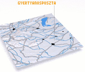 Places with similar names to Gyertyánospuszta, Hungary ::
// Gyertyánospuszta (HU)
// Gyertyánospuszta (HU)
Disclaimer :: Information on this page comes without warranty of any kind |
||
|
Where is Gyertyánospuszta? Elevation and coordinates ::
Latitude (lat): 47°22'0"N Longitude (lon): 16°43'0"E
Elevation (approx.): 231m (map arrows pan, magnifying glasses zoom) |
||
|
Visiting Gyertyánospuszta? Hotel/Accommodation ::
Book a hotel in Gyertyánospuszta Travel Guide ::
Buy a travel guide for Hungary rental cars ::
car rental offers GPS waypoint ::
download a GPX waypoint (PoI) of Gyertyánospuszta for your GPS receiver
|
||