|
search place name
|
||
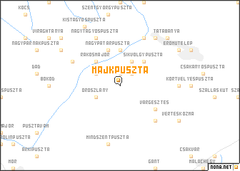
Majkpuszta (Komárom-Esztergom, Hungary)Majkpuszta is a town in the Komárom-Esztergom region of Hungary. An overview map of the region around Majkpuszta is displayed below.
regional and 3d topo map of Majkpuszta, Hungary ::
Majkpuszta airports ::
The nearest airport is BUD - Budapest Ferihegy, located 68.6 km east of Majkpuszta.
Other airports nearby include BTS - Bratislava M R Stefanik (113.1 km north west), PZY - Piestany (131.0 km north), SLD - Sliac (139.4 km north east), VIE - Vienna Schwechat (149.6 km north west), Nearby towns ::
Irtáspuszta (1.9km north) //
Vértessomló (2.2km north east) //
Környebánya (3.9km north) //
Felsőbányatelep (3.1km south west) //
Kecskéd (3.1km north west) //
Oroszlány (3.1km south west) //
Síkvölgypuszta (4.5km north east) //
Rákosmajor (4.5km north west) //
Fácánkert (5.6km north) //
Környemajor (5.7km north) //
Környe (5.7km north) //
Nagypatárpuszta (5.7km north) //
Várgesztes (5.3km south east) //
Kőhányás (6.7km south east) //
Bánhida (7.8km north) //
Nagytagyospuszta (7.8km north) //
Bellatanya (6.2km north west) //
Alsógalla (8.3km north east) //
Tatabánya (8.9km north east) //
[all distances 'as the bird flies' and approximate] 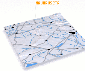 Places with similar names to Majkpuszta, Hungary ::
// Majkapuszta (HU)
Disclaimer :: Information on this page comes without warranty of any kind |
||
|
Where is Majkpuszta? Elevation and coordinates ::
Latitude (lat): 47°30'0"N Longitude (lon): 18°21'0"E
Elevation (approx.): 201m (map arrows pan, magnifying glasses zoom) |
||
|
Visiting Majkpuszta? Hotel/Accommodation ::
Book a hotel in Majkpuszta Travel Guide ::
Buy a travel guide for Hungary rental cars ::
car rental offers GPS waypoint ::
download a GPX waypoint (PoI) of Majkpuszta for your GPS receiver
|
||