|
search place name
|
||
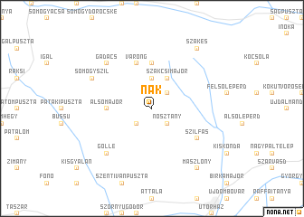
Nak (Tolna, Hungary)Nak is a town in the Tolna region of Hungary. An overview map of the region around Nak is displayed below.
regional and 3d topo map of Nak, Hungary ::
Nak airports ::
The nearest airport is OSI - Osijek, located 127.2 km south east of Nak.
Other airports nearby include BUD - Budapest Ferihegy (139.4 km north east), ZAG - Zagreb (175.0 km south west), BTS - Bratislava M R Stefanik (198.3 km north), VIE - Vienna Schwechat (213.4 km north west), Nearby towns ::
Nosztány (2.3km south east) //
Inámpuszta (2.3km south west) //
Borjád (2.3km north east) //
Lápafő (3.7km north) //
Szakcsimajor (3.9km north) //
Alsómajor (3.8km west) //
Rigótanya (5.6km north) //
Várong (5.7km north) //
Szilfás (5.3km south east) //
Cserepespuszta (6.8km south west) //
Gölle (6.8km south west) //
Gadács (6.7km north west) //
Kódé (6.3km north west) //
Somogyszil (6.3km north west) //
Alsómarosd (6.3km north west) //
Csérihegy (6.3km north west) //
Mászlony (8.3km south east) //
Szakes (8.3km north east) //
[all distances 'as the bird flies' and approximate] 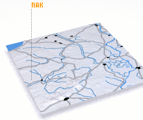 Places with similar names to Nak, Hungary ::
Disclaimer :: Information on this page comes without warranty of any kind |
||
|
Where is Nak? Elevation and coordinates ::
Latitude (lat): 46°29'0"N Longitude (lon): 18°4'0"E
Elevation (approx.): 151m (map arrows pan, magnifying glasses zoom) |
||
|
Visiting Nak? Hotel/Accommodation ::
Book a hotel in Nak Travel Guide ::
Buy a travel guide for Hungary rental cars ::
car rental offers GPS waypoint ::
download a GPX waypoint (PoI) of Nak for your GPS receiver
|
||