|
search place name
|
||
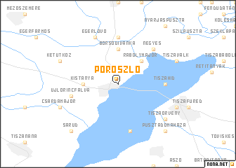
Poroszló (Heves, Hungary)Poroszló is a town in the Heves region of Hungary. An overview map of the region around Poroszló is displayed below.
regional and 3d topo map of Poroszló, Hungary ::
Poroszló airports ::
The nearest airport is DEB - Debrecen, located 73.6 km east of Poroszló.
Other airports nearby include BUD - Budapest Ferihegy (108.8 km west), OMR - Oradea (116.4 km south east), KSC - Kosice (120.5 km north), SLD - Sliac (158.3 km north west), Nearby towns ::
Rábolymajor (4.5km north east) //
Kistanya (3.7km west) //
Borsodivánka (5.6km north) //
Tiszahíd (5.0km east) //
Margittatanya (7.4km north) //
Óhalász (7.5km south) //
Újlőrincfalva (5.3km west) //
Négyes (6.7km north east) //
Egerlövő (7.8km north) //
Tiszaörvény (7.5km south east) //
Pusztadomaháza (8.9km south east) //
Sarud (8.9km south west) //
[all distances 'as the bird flies' and approximate] 
Disclaimer :: Information on this page comes without warranty of any kind |
||
|
Where is Poroszló? Elevation and coordinates ::
Latitude (lat): 47°39'0"N Longitude (lon): 20°40'0"E
Elevation (approx.): 90m (map arrows pan, magnifying glasses zoom) |
||
|
Visiting Poroszló? Hotel/Accommodation ::
Book a hotel in Poroszló Travel Guide ::
Buy a travel guide for Hungary rental cars ::
car rental offers GPS waypoint ::
download a GPX waypoint (PoI) of Poroszló for your GPS receiver
|
||