|
search place name
|
||
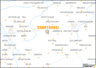
Rábatamási (Győr-Moson-Sopron, Hungary)Rábatamási is a town in the Győr-Moson-Sopron region of Hungary. An overview map of the region around Rábatamási is displayed below.
regional and 3d topo map of Rábatamási, Hungary ::
Rábatamási airports ::
The nearest airport is BTS - Bratislava M R Stefanik, located 65.3 km north of Rábatamási.
Other airports nearby include VIE - Vienna Schwechat (73.7 km north west), PZY - Piestany (125.9 km north east), GRZ - Graz (146.3 km south west), MBX - Maribor (166.5 km south west), Nearby towns ::
Borsodymajor (0.0km north) //
Bogyoszló (2.2km south east) //
Jobaháza (2.5km east) //
Potyond (3.9km south) //
Farád (3.1km north east) //
Sarlaymajor (3.9km north) //
Ostffymajor (5.6km north) //
Szárföld (4.2km north west) //
Magyarkeresztúr (7.4km south) //
Fölerdőmajor (7.4km south) //
Baditzmajor (7.4km south) //
Sopronnémeti (6.7km south east) //
Zsebeháza (7.8km south) //
Szilipuszta (8.3km south east) //
Mihályi (8.9km south west) //
Csatárimajor (8.9km north east) //
[all distances 'as the bird flies' and approximate]  Places with similar names to Rábatamási, Hungary :: Disclaimer :: Information on this page comes without warranty of any kind |
||
|
Where is Rábatamási? Elevation and coordinates ::
Latitude (lat): 47°35'0"N Longitude (lon): 17°10'0"E
Elevation (approx.): 120m (map arrows pan, magnifying glasses zoom) |
||
|
Visiting Rábatamási? Hotel/Accommodation ::
Book a hotel in Rábatamási Travel Guide ::
Buy a travel guide for Hungary rental cars ::
car rental offers GPS waypoint ::
download a GPX waypoint (PoI) of Rábatamási for your GPS receiver
|
||