|
search place name
|
||
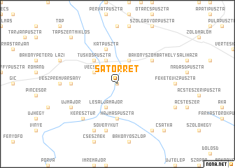
Sátorrét (Komárom-Esztergom, Hungary)Sátorrét is a town in the Komárom-Esztergom region of Hungary. An overview map of the region around Sátorrét is displayed below.
regional and 3d topo map of Sátorrét, Hungary ::
Sátorrét airports ::
The nearest airport is BTS - Bratislava M R Stefanik, located 97.4 km north west of Sátorrét.
Other airports nearby include BUD - Budapest Ferihegy (101.0 km east), VIE - Vienna Schwechat (125.9 km north west), PZY - Piestany (132.7 km north), SLD - Sliac (161.8 km north east), Nearby towns ::
Réde (0.0km north) //
Lesaljamajor (3.9km south) //
Gelegenyéspuszta (3.9km north) //
Bakonybánk (3.9km north) //
Vecseny (3.1km north west) //
Tuskóspuszta (4.5km north west) //
Hajmáspuszta (5.6km south) //
Kátpuszta (5.7km north) //
Bakonyszombathely (5.3km north east) //
Sikátor (5.0km west) //
Sövénykút (7.5km south) //
Keresztúr (6.7km south west) //
Bakonyszentkirály (7.8km south) //
Újmajor (6.2km south west) //
Koromla (8.3km south east) //
Csatka (9.0km south east) //
Tápszentmiklós (8.9km north west) //
[all distances 'as the bird flies' and approximate]  Places with similar names to Sátorrét, Hungary ::
// Start (RU)
// Staryye Atai (RU)
// Zaouia Taouert (MA)
// Zaouiat Ourti (MA)
// Sterrett (US)
// Strata (US)
// Stroud (US)
// Stuart (US)
// Strad (AT)
// Stuart (US)
Disclaimer :: Information on this page comes without warranty of any kind |
||
|
Where is Sátorrét? Elevation and coordinates ::
Latitude (lat): 47°26'0"N Longitude (lon): 17°55'0"E
Elevation (approx.): 186m (map arrows pan, magnifying glasses zoom) |
||
|
Visiting Sátorrét? Hotel/Accommodation ::
Book a hotel in Sátorrét Travel Guide ::
Buy a travel guide for Hungary rental cars ::
car rental offers GPS waypoint ::
download a GPX waypoint (PoI) of Sátorrét for your GPS receiver
|
||