|
search place name
|
||
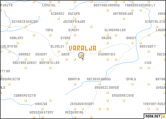
Váralja (Tolna, Hungary)Váralja is a town in the Tolna region of Hungary. An overview map of the region around Váralja is displayed below.
regional and 3d topo map of Váralja, Hungary ::
Váralja airports ::
The nearest airport is OSI - Osijek, located 94.0 km south of Váralja.
Other airports nearby include BUD - Budapest Ferihegy (144.4 km north east), BEG - Beograd (217.6 km south east), BTS - Bratislava M R Stefanik (230.9 km north west), VIE - Vienna Schwechat (248.9 km north west), Nearby towns ::
Háromház (0.0km north) //
Bányatelep (1.3km west) //
Máza (2.6km west) //
Nagymányok (3.2km north east) //
Györe (4.5km north west) //
Kismányok (3.8km east) //
Izmény (5.7km north) //
Ólvölgy (4.3km north west) //
Óbánya (5.7km south) //
Majos (5.3km north east) //
Erdőtelek (5.3km north east) //
Mecseknádasd (6.1km south east) //
Szászvár (5.1km west) //
Hidas (5.1km east) //
Józsefmajor (7.5km north) //
Aparhant (7.5km north) //
Bányatelep (5.5km west) //
Csöcskepuszta (6.8km north east) //
Tófů (7.6km north west) //
Glimermalom (7.6km north east) //
Vadászcsárda (8.4km south east) //
[all distances 'as the bird flies' and approximate] 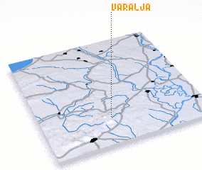 Places with similar names to Váralja, Hungary ::
Disclaimer :: Information on this page comes without warranty of any kind |
||
|
Where is Váralja? Elevation and coordinates ::
Latitude (lat): 46°16'0"N Longitude (lon): 18°26'0"E
Elevation (approx.): 174m (map arrows pan, magnifying glasses zoom) |
||
|
Visiting Váralja? Hotel/Accommodation ::
Book a hotel in Váralja Travel Guide ::
Buy a travel guide for Hungary rental cars ::
car rental offers GPS waypoint ::
download a GPX waypoint (PoI) of Váralja for your GPS receiver
|
||