|
search place name
|
||
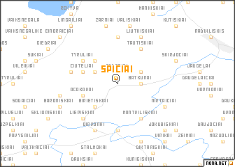
Spičiai (Lithuania)Spičiai is a town in Lithuania. An overview map of the region around Spičiai is displayed below.
regional and 3d topo map of Spičiai, Lithuania ::
Nearby towns ::
Gudesiai (1.9km north) //
Batkūnai (2.1km east) //
Polekėlė (2.8km north west) //
Bernočiai (2.8km north east) //
Pušiniškiai (4.3km north west) //
Birietiškiai (4.3km south west) //
Acokavai (3.6km south west) //
Čiuteliai (3.6km north west) //
Tyruliai (4.8km north west) //
Pušynkalnis (4.8km north west) //
Tautiškiai (5.9km north) //
Mantviliškiai (5.9km south) //
Šiaulėnai (7.4km south) //
Jonaitiškiai (7.4km north) //
Vendrė (4.6km north west) //
Liepiškiai (6.4km south west) //
Dirvonai (7.7km south) //
Liutkiškiai (7.7km north) //
Nirtaičiai (5.6km south east) //
Jokūbiškiai (8.5km south east) //
[all distances 'as the bird flies' and approximate] 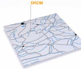 Places with similar names to Spičiai, Lithuania ::
// Supych (RU)
// Sypuchi (RU)
// Saopa Chai (MM)
// Saopa Chai (MM)
// Spich (DE)
// Spich (DE)
// Spítia (GR)
// Sapiechów (PL)
// Sępichów (PL)
// Sępochów (PL)
Disclaimer :: Information on this page comes without warranty of any kind |
||
|
Where is Spičiai? Elevation and coordinates ::
Latitude (lat): 55°45'0"N Longitude (lon): 23°24'0"E
Elevation (approx.): 121m (map arrows pan, magnifying glasses zoom) |
||
|
Visiting Spičiai? Hotel/Accommodation ::
Book a hotel in Spičiai Travel Guide ::
Buy a travel guide for Lithuania rental cars ::
car rental offers GPS waypoint ::
download a GPX waypoint (PoI) of Spičiai for your GPS receiver
|
||