|
search place name
|
||
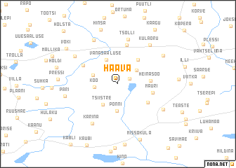
Haava (Võrumaa, Estonia)Haava is a town in the Võrumaa region of Estonia. An overview map of the region around Haava is displayed below.
regional and 3d topo map of Haava, Estonia ::
Nearby towns ::
Kirikumäe (1.3km north east) //
Perametsa (2.7km north east) //
Kõo (2.1km west) //
Tsiistre (3.5km south) //
Kündja (2.6km north west) //
Põnni (4.3km south) //
Vana-Saaluse (4.0km north) //
Jeedasküla (4.2km north east) //
Heinasoo (2.8km east) //
Möldre (3.9km south east) //
Mauri (3.3km south east) //
Petruse (4.1km north west) //
Juraski (6.2km north) //
Tsolli (7.1km north) //
Kärina (6.6km south) //
Külaoru (6.7km north east) //
Halla (7.3km north) //
Paloveere (5.7km north west) //
Pältre (5.6km south east) //
Vastseliina (6.0km north east) //
Pari (4.9km south west) //
Hinsa (8.7km north) //
Missoküla (9.1km south) //
Voki (7.2km north west) //
Kaagu (9.2km north) //
Holsta (9.6km north west) //
[all distances 'as the bird flies' and approximate] 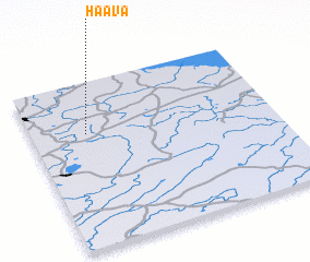 Places with similar names to Haava, Estonia ::
Disclaimer :: Information on this page comes without warranty of any kind |
||
|
Where is Haava? Elevation and coordinates ::
Latitude (lat): 57°41'20"N Longitude (lon): 27°13'43"E
Elevation (approx.): 194m (map arrows pan, magnifying glasses zoom) |
||
|
Visiting Haava? Hotel/Accommodation ::
Book a hotel in Haava Travel Guide ::
Buy a travel guide for Estonia rental cars ::
car rental offers GPS waypoint ::
download a GPX waypoint (PoI) of Haava for your GPS receiver
|
||