|
search place name
|
||
Jämaja (Saaremaa, Estonia)Jämaja is a town in the Saaremaa region of Estonia. An overview map of the region around Jämaja is displayed below.
regional and 3d topo map of Jämaja, Estonia ::
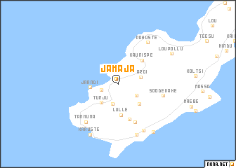
Nearby towns ::
Ohesaare (1.6km south west) //
Laadla (3.2km south) //
Mõisaküla (2.4km south east) //
Kargi (2.3km north east) //
Türju (3.4km south west) //
Jaandi (2.4km west) //
Torgu (3.7km south east) //
Lülle (4.9km south) //
Kaunispe (4.3km north east) //
Kahusaadu (5.6km south) //
Hänga (6.2km south) //
Soodevahe (4.3km south east) //
Tammuna (6.6km south west) //
Rahuste (7.0km north) //
Maantee (7.8km south) //
Sääre (8.2km south) //
Karuste (8.3km south) //
Läbara (8.2km south) //
Lõupõllu (6.6km north east) //
[all distances 'as the bird flies' and approximate] 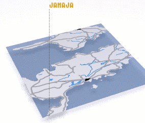 Places with similar names to Jämaja, Estonia ::
Disclaimer :: Information on this page comes without warranty of any kind |
||
|
Where is Jämaja? Elevation and coordinates ::
Latitude (lat): 58°0'19"N Longitude (lon): 22°3'24"E
Elevation (approx.): 8m (map arrows pan, magnifying glasses zoom) |
||
|
Visiting Jämaja? Hotel/Accommodation ::
Book a hotel in Jämaja Travel Guide ::
Buy a travel guide for Estonia rental cars ::
car rental offers GPS waypoint ::
download a GPX waypoint (PoI) of Jämaja for your GPS receiver
|
||