|
search place name
|
||
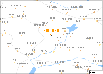
Kääriku (Valgamaa, Estonia)Kääriku is a town in the Valgamaa region of Estonia. An overview map of the region around Kääriku is displayed below.
regional and 3d topo map of Kääriku, Estonia ::
Kääriku airports ::
The nearest airport is TLL - Tallinn-ulemiste International Tallinn, located 181.5 km north west of Kääriku.
Nearby towns ::
Märdi (1.8km south east) //
Voki (2.6km north east) //
Arula (4.3km north) //
Kassiratta (4.1km south east) //
Sihva (3.4km north east) //
Risttee (5.1km south) //
Ristiotsa (5.5km south) //
Vanamõisa (4.3km north west) //
Mäha (6.0km north) //
Restu (6.2km south) //
Raudsepa (3.6km east) //
Mäeküla (5.0km south west) //
Pühajärve (6.4km north east) //
Ilmjärve (5.9km south east) //
Tsäni (6.5km south west) //
Pedajamäe (9.0km north) //
Kurevere (8.3km south west) //
Sangaste (9.4km south west) //
[all distances 'as the bird flies' and approximate]  Places with similar names to Kääriku, Estonia ::
Disclaimer :: Information on this page comes without warranty of any kind |
||
|
Where is Kääriku? Elevation and coordinates ::
Latitude (lat): 57°59'58"N Longitude (lon): 26°23'28"E
Elevation (approx.): 138m (map arrows pan, magnifying glasses zoom) |
||
|
Visiting Kääriku? Hotel/Accommodation ::
Book a hotel in Kääriku Travel Guide ::
Buy a travel guide for Estonia rental cars ::
car rental offers GPS waypoint ::
download a GPX waypoint (PoI) of Kääriku for your GPS receiver
|
||