|
search place name
|
||
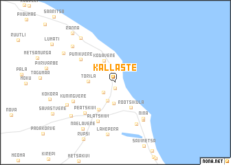
Kallaste (Tartumaa, Estonia)Kallaste is a town in the Tartumaa region of Estonia. An overview map of the region around Kallaste is displayed below.
regional and 3d topo map of Kallaste, Estonia ::
Nearby towns ::
Pusi (0.9km south) //
Haapsipea (1.9km south west) //
Pärsikivi (2.8km north) //
Virtsu (3.1km south) //
Alasoo (3.4km south) //
Kodavere (3.7km north) //
Torila (2.3km west) //
Rootsiküla (4.3km south) //
Kõdesi (4.6km south) //
Punikvere (4.8km north west) //
Alatskivi (6.5km south) //
Peatskivi (5.6km south west) //
Nina (6.3km south) //
Kuningvere (4.7km south west) //
Riidma (6.9km south) //
Krundiküla (6.6km south) //
Lahepera (8.4km south) //
Tõruvere (5.5km south west) //
Päiksi (6.6km south west) //
Sassukvere (6.8km north west) //
Äteniidi (7.7km north) //
Naelavere (8.0km south) //
Kadrina (6.5km north west) //
Ranna (8.8km north west) //
[all distances 'as the bird flies' and approximate]  Places with similar names to Kallaste, Estonia ::
Disclaimer :: Information on this page comes without warranty of any kind |
||
|
Where is Kallaste? Elevation and coordinates ::
Latitude (lat): 58°39'18"N Longitude (lon): 27°9'33"E
Elevation (approx.): 43m (map arrows pan, magnifying glasses zoom) |
||
|
Visiting Kallaste? Hotel/Accommodation ::
Book a hotel in Kallaste Travel Guide ::
Buy a travel guide for Estonia rental cars ::
car rental offers GPS waypoint ::
download a GPX waypoint (PoI) of Kallaste for your GPS receiver
|
||