|
search place name
|
||
Kellamäe (Saaremaa, Estonia)Kellamäe is a town in the Saaremaa region of Estonia. An overview map of the region around Kellamäe is displayed below.
regional and 3d topo map of Kellamäe, Estonia ::
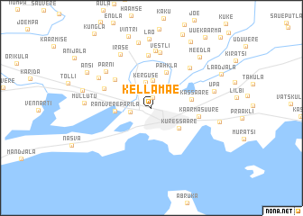
Nearby towns ::
Unimäe (1.3km north) //
Laheküla (1.5km west) //
Kerguse (3.2km north) //
Pähkla Asundus (3.4km north) //
Kuressaare (3.1km south east) //
Randvere-Parila (2.4km west) //
Pähkla (4.5km north) //
Sikassaare (2.8km north east) //
Põllu (4.2km north west) //
Kaarma-Suure (3.3km east) //
Viira (3.9km north west) //
Saia (6.5km north) //
Maleva (5.6km north east) //
Vestli (6.9km north) //
Sepa (7.1km north) //
Pärni (5.4km north west) //
Randvere (5.1km north west) //
Irase (7.0km north) //
Upa (4.6km north east) //
Aste (8.1km north) //
Mullutu (4.4km west) //
Kudjape (4.8km east) //
Lao (8.6km north) //
Meedla (7.0km north east) //
Tamsalu (5.0km north west) //
Ansi (6.1km north west) //
Kaarma (8.6km north) //
Laadjala (6.2km north east) //
Uue-Kaarma (9.4km north) //
[all distances 'as the bird flies' and approximate] 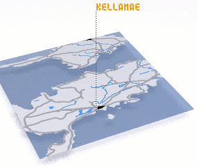 Places with similar names to Kellamäe, Estonia ::
Disclaimer :: Information on this page comes without warranty of any kind |
||
|
Where is Kellamäe? Elevation and coordinates ::
Latitude (lat): 58°16'16"N Longitude (lon): 22°28'25"E
Elevation (approx.): 5m (map arrows pan, magnifying glasses zoom) |
||
|
Visiting Kellamäe? Hotel/Accommodation ::
Book a hotel in Kellamäe Travel Guide ::
Buy a travel guide for Estonia rental cars ::
car rental offers GPS waypoint ::
download a GPX waypoint (PoI) of Kellamäe for your GPS receiver
|
||