|
search place name
|
||
Luutsniku (Võrumaa, Estonia)Luutsniku is a town in the Võrumaa region of Estonia. An overview map of the region around Luutsniku is displayed below.
regional and 3d topo map of Luutsniku, Estonia ::
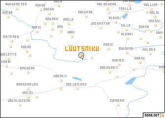
Nearby towns ::
Kilomani (1.1km east) //
Palli (2.2km north west) //
Haki (5.2km north) //
Raagi (3.9km north east) //
Mäemurati (4.3km south east) //
Veclaicene (6.7km south) //
Korneti (5.5km south west) //
Oru (6.8km north west) //
Jugumetsa (7.5km north) //
Sarise (4.6km east) //
Bārdas (7.2km south) //
Mõõlu (8.1km north) //
Murati (5.7km south east) //
Kaveldi (6.5km north west) //
Viitina (7.7km north west) //
Kääraku (7.6km north east) //
Orumäe (8.9km north west) //
Plaksi (9.3km north east) //
Heibri (9.3km north west) //
[all distances 'as the bird flies' and approximate] 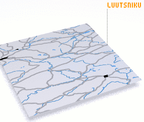 Places with similar names to Luutsniku, Estonia ::
// Laitzing (AT)
// Leitzing (AT)
// Lađašinica (BA)
// Latišonki (LV)
// Ludžinieki (LV)
// Lutsenki (UA)
// Leitzing (DE)
// (( Lutsenko )) (RU)
Disclaimer :: Information on this page comes without warranty of any kind |
||
|
Where is Luutsniku? Elevation and coordinates ::
Latitude (lat): 57°37'36"N Longitude (lon): 26°59'40"E
Elevation (approx.): 167m (map arrows pan, magnifying glasses zoom) |
||
|
Visiting Luutsniku? Hotel/Accommodation ::
Book a hotel in Luutsniku Travel Guide ::
Buy a travel guide for Estonia rental cars ::
car rental offers GPS waypoint ::
download a GPX waypoint (PoI) of Luutsniku for your GPS receiver
|
||