|
search place name
|
||
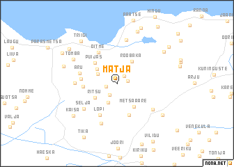
Mätja (Saaremaa, Estonia)Mätja is a town in the Saaremaa region of Estonia. An overview map of the region around Mätja is displayed below.
regional and 3d topo map of Mätja, Estonia ::
Mätja airports ::
The nearest airport is TKU - Turku, located 223.9 km north of Mätja.
Nearby towns ::
Nihatu (1.4km north east) //
Aruste (1.0km north east) //
Taresti (1.0km south west) //
Sülla (1.0km south west) //
Pärsama (1.9km south) //
Külma (3.1km south) //
Viira (2.2km north west) //
Õeste (2.9km north west) //
Ritsu (2.9km south west) //
Roobaka (3.8km north) //
Metsaääre (4.0km south) //
Puijas (3.8km north west) //
Koikla (5.1km south) //
Kopli (2.9km west) //
Lõpi (5.2km south) //
Angla (3.1km west) //
Oitme (5.3km north) //
Aru (3.6km north west) //
Selja (4.9km south west) //
Karja (3.6km west) //
Räägi (6.5km south) //
Aru (5.1km south east) //
Mujaste (7.0km north) //
Tomba (5.3km north west) //
Kaisa (6.3km south west) //
Ratla (6.2km south east) //
Jõiste (8.5km north) //
Triigi (7.5km north west) //
Veske (5.3km north west) //
[all distances 'as the bird flies' and approximate] 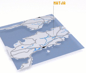 Places with similar names to Mätja, Estonia ::
Disclaimer :: Information on this page comes without warranty of any kind |
||
|
Where is Mätja? Elevation and coordinates ::
Latitude (lat): 58°31'13"N Longitude (lon): 22°45'57"E
Elevation (approx.): 11m (map arrows pan, magnifying glasses zoom) |
||
|
Visiting Mätja? Hotel/Accommodation ::
Book a hotel in Mätja Travel Guide ::
Buy a travel guide for Estonia rental cars ::
car rental offers GPS waypoint ::
download a GPX waypoint (PoI) of Mätja for your GPS receiver
|
||