|
search place name
|
||
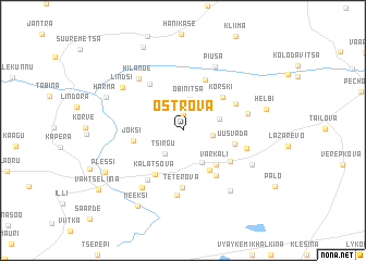
Ostrova (Võrumaa, Estonia)Ostrova is a town in the Võrumaa region of Estonia. An overview map of the region around Ostrova is displayed below.
regional and 3d topo map of Ostrova, Estonia ::
Nearby towns ::
Rokina (1.8km north) //
Tsirgu (2.6km south) //
Tääglova (2.9km north) //
Tobrova (1.7km east) //
Obinitsa (3.2km north) //
Palande (3.4km south) //
Küllatova (2.3km north east) //
Varkali (3.9km south east) //
Meremäe (4.3km south) //
Jõksi (2.9km west) //
Kalatsova (4.7km south) //
Korski (4.0km north east) //
Uusvada (3.1km south east) //
Kiksova (5.3km north) //
Kerba (4.9km south) //
Serga (4.1km south east) //
Teterova (5.8km south) //
Andrikova (5.1km north) //
Polovina (4.0km north east) //
Ruutsi (5.4km south) //
Kiislova (6.6km south) //
Kitse (3.9km south east) //
Veretina (4.0km north east) //
Hilande (5.9km north west) //
Kuksina (6.3km south) //
Piusa (6.7km north) //
Lindsi (5.5km north west) //
Kuige (6.7km south east) //
Vinski (5.2km south east) //
[all distances 'as the bird flies' and approximate]  Places with similar names to Ostrova, Estonia ::
Disclaimer :: Information on this page comes without warranty of any kind |
||
|
Where is Ostrova? Elevation and coordinates ::
Latitude (lat): 57°46'53"N Longitude (lon): 27°26'10"E
Elevation (approx.): 126m (map arrows pan, magnifying glasses zoom) |
||
|
Visiting Ostrova? Hotel/Accommodation ::
Book a hotel in Ostrova Travel Guide ::
Buy a travel guide for Estonia rental cars ::
car rental offers GPS waypoint ::
download a GPX waypoint (PoI) of Ostrova for your GPS receiver
|
||