|
search place name
|
||
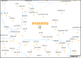
Pikakannu (Võrumaa, Estonia)Pikakannu is a town in the Võrumaa region of Estonia. An overview map of the region around Pikakannu is displayed below.
regional and 3d topo map of Pikakannu, Estonia ::
Nearby towns ::
Virve (1.3km north west) //
Otsa (2.8km south) //
Kõrgessaare (2.7km north) //
Lihtensteini (5.6km north) //
Hellekunnu (5.1km south) //
Jantra (3.5km east) //
Lasva (3.9km west) //
Sutte (7.0km south) //
Kunksilla (6.7km north) //
Pindi (4.4km north west) //
Madala (4.7km north east) //
Lepassaare (4.9km south east) //
Loosi (8.0km south) //
Paidra (6.2km north west) //
Husari (5.5km south west) //
Puutli (8.8km south) //
Leevi (8.6km north) //
Sooküla (7.8km south west) //
Tabina (7.6km south east) //
Tilga (8.5km south west) //
Jõeveere (8.9km north west) //
[all distances 'as the bird flies' and approximate] 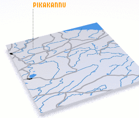 Places with similar names to Pikakannu, Estonia ::
// Pagagon (MM)
// Poggio Cono (IT)
// Poćućani (BA)
// Pokagon (US)
// Pacakan (ID)
// Pegagan (ID)
// Pocogan (ID)
// Pagaukane (PG)
// Pagaukane (PG)
// Poggio a Caiano (IT)
Disclaimer :: Information on this page comes without warranty of any kind |
||
|
Where is Pikakannu? Elevation and coordinates ::
Latitude (lat): 57°52'20"N Longitude (lon): 27°14'51"E
Elevation (approx.): 99m (map arrows pan, magnifying glasses zoom) |
||
|
Visiting Pikakannu? Hotel/Accommodation ::
Book a hotel in Pikakannu Travel Guide ::
Buy a travel guide for Estonia rental cars ::
car rental offers GPS waypoint ::
download a GPX waypoint (PoI) of Pikakannu for your GPS receiver
|
||