|
search place name
|
||
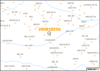
Vahakõnnu (Raplamaa, Estonia)Vahakõnnu is a town in the Raplamaa region of Estonia. An overview map of the region around Vahakõnnu is displayed below.
regional and 3d topo map of Vahakõnnu, Estonia ::
Vahakõnnu airports ::
The nearest airport is TLL - Tallinn-ulemiste International Tallinn, located 63.3 km north of Vahakõnnu.
Other airports nearby include HEM - Helsinki Malmi (157.6 km north), HEL - Helsinki Vantaa (164.2 km north), Nearby towns ::
Vaharu (1.1km west) //
Lihuveski (2.7km south) //
Männiku (2.3km north west) //
Purku (4.4km north) //
Laeste (4.3km north) //
Kaera (4.1km north west) //
Isakõnnu (5.8km south) //
Lellapere (5.6km north) //
Järvakandi (3.9km north west) //
Sooaluste (6.9km north) //
Järvakandi (6.3km north) //
Põlma (6.7km north) //
Ahekõnnu (5.2km south east) //
Vastja (3.9km east) //
Mallukse (4.2km west) //
Uusküla (7.8km north) //
Türgiküla (4.4km north west) //
Järvakandi (7.5km south) //
Hiienurme (7.8km north) //
Käbiküla (7.6km north) //
Kärpla (5.8km north east) //
Valli (5.4km north west) //
Allika (6.1km south west) //
Keo (7.1km north west) //
Kokuta (6.1km north east) //
Kalbu (7.6km north east) //
[all distances 'as the bird flies' and approximate] 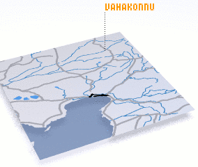
Disclaimer :: Information on this page comes without warranty of any kind |
||
|
Where is Vahakõnnu? Elevation and coordinates ::
Latitude (lat): 58°50'44"N Longitude (lon): 24°48'6"E
Elevation (approx.): 58m (map arrows pan, magnifying glasses zoom) |
||
|
Visiting Vahakõnnu? Hotel/Accommodation ::
Book a hotel in Vahakõnnu Travel Guide ::
Buy a travel guide for Estonia rental cars ::
car rental offers GPS waypoint ::
download a GPX waypoint (PoI) of Vahakõnnu for your GPS receiver
|
||