|
search place name
|
||
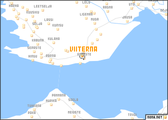
Viiterna (Hiiumaa, Estonia)Viiterna is a town in the Hiiumaa region of Estonia. An overview map of the region around Viiterna is displayed below.
regional and 3d topo map of Viiterna, Estonia ::
Viiterna airports ::
The nearest airport is TKU - Turku, located 203.1 km north of Viiterna.
Nearby towns ::
Emmaste (0.4km north) //
Tärkma (0.9km south west) //
Kõmmuselja (1.9km north) //
Prassi (2.4km north) //
Harju-Männiku (3.8km north) //
Metsalauka (2.7km north west) //
Riidaküla (3.0km north west) //
Rannaküla (2.9km south west) //
Harju (4.8km north) //
Valgu (6.1km north) //
Lepiku (3.7km west) //
Pärna (3.9km west) //
Ulja (7.0km north) //
Viiri (4.0km west) //
Külama (5.2km north west) //
Muda (8.3km north) //
Kurisu (7.6km north west) //
Pammana (9.3km south) //
Lassi (9.1km north west) //
[all distances 'as the bird flies' and approximate] 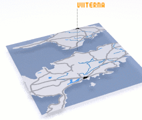 Places with similar names to Viiterna, Estonia ::
Disclaimer :: Information on this page comes without warranty of any kind |
||
|
Where is Viiterna? Elevation and coordinates ::
Latitude (lat): 58°42'0"N Longitude (lon): 22°37'0"E
Elevation (approx.): 8m (map arrows pan, magnifying glasses zoom) |
||
|
Visiting Viiterna? Hotel/Accommodation ::
Book a hotel in Viiterna Travel Guide ::
Buy a travel guide for Estonia rental cars ::
car rental offers GPS waypoint ::
download a GPX waypoint (PoI) of Viiterna for your GPS receiver
|
||