|
search place name
|
||
Costanera (Ciego de Ávila, Cuba)Costanera is a town in the Ciego de Ávila region of Cuba. An overview map of the region around Costanera is displayed below.
regional and 3d topo map of Costanera, Cuba ::

Costanera airports ::
The nearest airport is AVI - Ciego De Avila Maximo Gomez, located 32.9 km south east of Costanera.
Other airports nearby include SNU - Santa Clara Abel Santamaria (107.9 km west), CMW - Camaguey Ignacio Agramonte Intl (147.3 km south east), CFG - Cienfuegos Jaime Gonzalez (155.3 km west), VTU - Las Tunas Hermanos Ameijeiras (251.3 km south east), Nearby towns ::
Macagual (1.9km south) //
Vegas Viejas (3.9km north east) //
Corral (3.9km north east) //
Morris (5.1km south east) //
El Júcaro (5.8km north) //
Asiento (6.6km south east) //
Los Perros (6.8km north east) //
Cienfuegos de Cruz (7.4km south) //
Eugenia (7.1km west) //
Administración (7.6km south east) //
El Mango (7.8km south west) //
[all distances 'as the bird flies' and approximate] 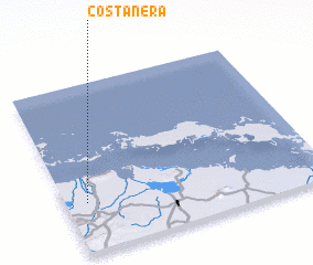 Places with similar names to Costanera, Cuba ::
// Kestenar (BA)
// Kestenar (BA)
// Castañeira (ES)
// Castañeirúa (ES)
// Castañera (ES)
// Castañera (ES)
// Castañera (ES)
// Castañera (ES)
// Castañera (ES)
// Castañera (ES)
Disclaimer :: Information on this page comes without warranty of any kind |
||
|
Where is Costanera? Elevation and coordinates ::
Latitude (lat): 22°18'0"N Longitude (lon): 78°55'0"W
Elevation (approx.): 14m (map arrows pan, magnifying glasses zoom) |
||
|
Visiting Costanera? Hotel/Accommodation ::
Book a hotel in Costanera Travel Guide ::
Buy a travel guide for Cuba rental cars ::
car rental offers GPS waypoint ::
download a GPX waypoint (PoI) of Costanera for your GPS receiver
|
||