|
search place name
|
||
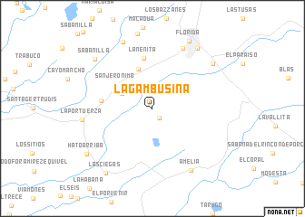
La Gambusina (Camagüey, Cuba)La Gambusina is a town in the Camagüey region of Cuba. An overview map of the region around La Gambusina is displayed below.
regional and 3d topo map of La Gambusina, Cuba ::
La Gambusina airports ::
The nearest airport is CMW - Camaguey Ignacio Agramonte Intl, located 43.6 km east of La Gambusina.
Other airports nearby include AVI - Ciego De Avila Maximo Gomez (83.7 km north west), VTU - Las Tunas Hermanos Ameijeiras (147.3 km east), MZO - Manzanillo Sierra Maestra (177.6 km south east), BYM - Bayamo Carlos Manuel De Cespedes (207.1 km south east), Nearby towns ::
El Perú (1.0km north) //
San Salvador (1.4km south east) //
San Clemente (3.9km north west) //
Dos Hermanas (5.1km north) //
San Jerónimo (5.2km north west) //
La Nenita (6.3km north) //
San Juan Bosco (5.9km west) //
San Emilio (8.2km north east) //
La Portuerza (8.2km west) //
Vista Hermosa (8.8km north) //
Amelia (8.8km south east) //
Mercedes (9.0km north east) //
San Lorenzo (9.0km north east) //
Alturas del San Juan (8.9km north east) //
Sabanilla (9.0km north west) //
Florida (9.3km north east) //
Las Ciegas (9.6km south west) //
Hato Arriba (9.4km south west) //
[all distances 'as the bird flies' and approximate]  Places with similar names to La Gambusina, Cuba ::
// La Comesón (CU)
Disclaimer :: Information on this page comes without warranty of any kind |
||
|
Where is La Gambusina? Elevation and coordinates ::
Latitude (lat): 21°27'0"N Longitude (lon): 78°16'0"W
Elevation (approx.): 43m (map arrows pan, magnifying glasses zoom) |
||
|
Visiting La Gambusina? Hotel/Accommodation ::
Book a hotel in La Gambusina Travel Guide ::
Buy a travel guide for Cuba rental cars ::
car rental offers GPS waypoint ::
download a GPX waypoint (PoI) of La Gambusina for your GPS receiver
|
||