|
search place name
|
||
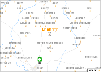
La Santa (Las Tunas, Cuba)La Santa is a town in the Las Tunas region of Cuba. An overview map of the region around La Santa is displayed below.
regional and 3d topo map of La Santa, Cuba ::
La Santa airports ::
The nearest airport is VTU - Las Tunas Hermanos Ameijeiras, located 9.5 km south west of La Santa.
Other airports nearby include HOG - Holguin Frank Pais Intl (68.3 km south east), BYM - Bayamo Carlos Manuel De Cespedes (79.7 km south), MZO - Manzanillo Sierra Maestra (88.4 km south), CMW - Camaguey Ignacio Agramonte Intl (105.9 km west), Nearby towns ::
González (2.5km north east) //
Santa María de Manzanillo (3.7km south) //
Manzanillo Adentro (4.1km north west) //
El Almendrón (5.1km north west) //
Collada (5.1km north west) //
Reyes (5.6km south) //
Macuto (5.8km north) //
Managua (6.4km north west) //
Mariátegui (7.4km north) //
Santa Teresa (7.2km east) //
Caisimú (7.6km north west) //
Riecito (10.1km north west) //
Cabrera (10.1km north east) //
[all distances 'as the bird flies' and approximate] 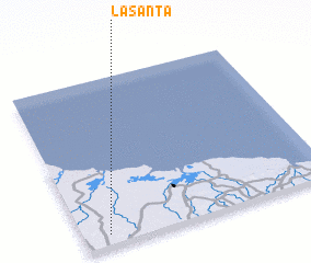 Places with similar names to La Santa, Cuba ::
Disclaimer :: Information on this page comes without warranty of any kind |
||
|
Where is La Santa? Elevation and coordinates ::
Latitude (lat): 21°4'0"N Longitude (lon): 76°54'0"W
Elevation (approx.): 67m (map arrows pan, magnifying glasses zoom) |
||
|
Visiting La Santa? Hotel/Accommodation ::
Book a hotel in La Santa Travel Guide ::
Buy a travel guide for Cuba rental cars ::
car rental offers GPS waypoint ::
download a GPX waypoint (PoI) of La Santa for your GPS receiver
|
||