|
search place name
|
||
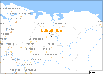
Los Güiros (Holguín, Cuba)Los Güiros is a town in the Holguín region of Cuba. An overview map of the region around Los Güiros is displayed below.
regional and 3d topo map of Los Güiros, Cuba ::
Los Güiros airports ::
The nearest airport is MOA - Moa Orestes Acosta, located 19.0 km east of Los Güiros.
Other airports nearby include GAO - Guantanamo Mariana Grajales (59.1 km south), BCA - Baracoa Playa Gustavo Rizo (67.9 km south east), SCU - Santiago De Cuba Antonio Maceo Intl (105.0 km south west), HOG - Holguin Frank Pais Intl (128.0 km west), Nearby towns ::
Cananova (1.2km north) //
Barbarú (1.7km west) //
Canoa (3.7km south) //
Yaguaneque (5.1km north east) //
Melena (5.1km north west) //
La Yuita (5.8km south) //
Los Calderos (5.5km west) //
Cebolla (6.4km north west) //
Arroyo Blanco (6.4km south west) //
Los Guineos (7.4km south) //
La Cuchilla (7.2km west) //
Batey (8.2km south east) //
El Sitio (7.9km south west) //
El Cacao (8.9km south west) //
La Penda (9.1km south west) //
[all distances 'as the bird flies' and approximate] 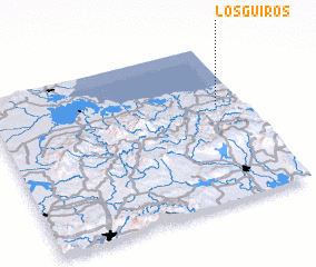 Places with similar names to Los Güiros, Cuba ::
// Los Chorros (PA)
// Łaskarzew (PL)
// Lisikierz (PL)
// Los Güiros (CU)
// Lascorz (ES)
// Los Curas (ES)
// Los Currás (ES)
// Los Curros (ES)
// Los Garres (ES)
// Los Guirres (ES)
Disclaimer :: Information on this page comes without warranty of any kind |
||
|
Where is Los Güiros? Elevation and coordinates ::
Latitude (lat): 20°37'0"N Longitude (lon): 75°6'0"W
Elevation (approx.): 35m (map arrows pan, magnifying glasses zoom) |
||
|
Visiting Los Güiros? Hotel/Accommodation ::
Book a hotel in Los Güiros Travel Guide ::
Buy a travel guide for Cuba rental cars ::
car rental offers GPS waypoint ::
download a GPX waypoint (PoI) of Los Güiros for your GPS receiver
|
||