|
search place name
|
||
Mestanza (Pinar del Río, Cuba)Mestanza is a town in the Pinar del Río region of Cuba. An overview map of the region around Mestanza is displayed below.
regional and 3d topo map of Mestanza, Cuba ::

Mestanza airports ::
The nearest airport is LCL - La Coloma, located 19.3 km south east of Mestanza.
Other airports nearby include GER - Nueva Gerona Rafael Cabrera (123.6 km south east), HAV - Havana Jose Marti Intl (153.3 km north east), Nearby towns ::
El Cangre (1.7km south east) //
Piedra (2.5km south east) //
El Guayabo (3.7km south) //
Valle Isabel María (3.6km north west) //
Palmarito (3.9km south east) //
Ceiba (3.9km south east) //
Los Mangos (3.9km south east) //
Envidia (4.1km south west) //
Moncada (5.0km north west) //
El Rancho (5.6km south) //
Cana Alta (6.3km south east) //
Isabel María (7.2km north west) //
Cuajaní (7.8km north east) //
Vista Hermosa (8.3km south) //
Mulo (7.9km west) //
Cabeza (8.6km west) //
[all distances 'as the bird flies' and approximate] 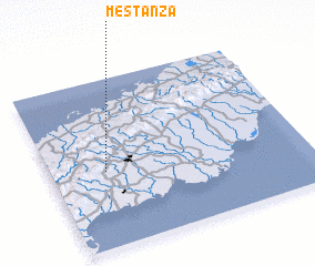 Places with similar names to Mestanza, Cuba ::
Disclaimer :: Information on this page comes without warranty of any kind |
||
|
Where is Mestanza? Elevation and coordinates ::
Latitude (lat): 22°27'0"N Longitude (lon): 83°47'0"W
Elevation (approx.): 161m (map arrows pan, magnifying glasses zoom) |
||
|
Visiting Mestanza? Hotel/Accommodation ::
Book a hotel in Mestanza Travel Guide ::
Buy a travel guide for Cuba rental cars ::
car rental offers GPS waypoint ::
download a GPX waypoint (PoI) of Mestanza for your GPS receiver
|
||