|
search place name
|
||
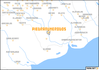
Piedra Número Dos (Pinar del Río, Cuba)Piedra Número Dos is a town in the Pinar del Río region of Cuba. An overview map of the region around Piedra Número Dos is displayed below.
regional and 3d topo map of Piedra Número Dos, Cuba ::
Piedra Número Dos airports ::
The nearest airport is LCL - La Coloma, located 69.8 km south west of Piedra Número Dos.
Other airports nearby include HAV - Havana Jose Marti Intl (76.6 km north east), GER - Nueva Gerona Rafael Cabrera (88.2 km south), VRA - Varadero Juan Gualberto Gomez Intl (170.2 km east), CYO - Cayo Vilo Acuna Intl (187.4 km south east), Nearby towns ::
Piedra Número Uno (1.6km north) //
La Verbena (1.8km south west) //
Piedra (2.2km north east) //
El Pinar (6.2km south) //
Mayarí (7.6km north) //
Revocadero (8.3km north west) //
Piloto (8.7km north east) //
Embarcadero Cantón (8.3km east) //
[all distances 'as the bird flies' and approximate]  Places with similar names to Piedra Número Dos, Cuba :: Disclaimer :: Information on this page comes without warranty of any kind |
||
|
Where is Piedra Número Dos? Elevation and coordinates ::
Latitude (lat): 22°35'55"N Longitude (lon): 83°1'30"W
Elevation (approx.): 14m (map arrows pan, magnifying glasses zoom) |
||
|
Visiting Piedra Número Dos? Hotel/Accommodation ::
Book a hotel in Piedra Número Dos Travel Guide ::
Buy a travel guide for Cuba rental cars ::
car rental offers GPS waypoint ::
download a GPX waypoint (PoI) of Piedra Número Dos for your GPS receiver
|
||