|
search place name
|
||
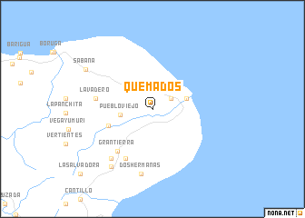
Quemados (Guantánamo, Cuba)Quemados is a town in the Guantánamo region of Cuba. An overview map of the region around Quemados is displayed below.
regional and 3d topo map of Quemados, Cuba ::
Quemados airports ::
The nearest airport is BCA - Baracoa Playa Gustavo Rizo, located 36.2 km north west of Quemados.
Other airports nearby include MOA - Moa Orestes Acosta (89.4 km north west), IGA - Matthew Town (97.9 km north east), GAO - Guantanamo Mariana Grajales (102.9 km west), SCU - Santiago De Cuba Antonio Maceo Intl (174.9 km west), Nearby towns ::
Cuesta Chivo (2.5km north east) //
Pueblo Viejo (3.8km west) //
Maisí (4.1km east) //
Puriales (5.5km west) //
Gran Tierra (6.6km south west) //
Hacienda Gran Tierra (6.8km south west) //
Lavadero (6.7km west) //
La Maya (7.8km south west) //
Dos Hermanas (8.1km south) //
La Asunción (8.5km south west) //
Sabana (9.1km north west) //
La Salvadora (11.5km south west) //
[all distances 'as the bird flies' and approximate]  Places with similar names to Quemados, Cuba ::
Disclaimer :: Information on this page comes without warranty of any kind |
||
|
Where is Quemados? Elevation and coordinates ::
Latitude (lat): 20°14'18"N Longitude (lon): 74°11'14"W
Elevation (approx.): 61m (map arrows pan, magnifying glasses zoom) |
||
|
Visiting Quemados? Hotel/Accommodation ::
Book a hotel in Quemados Travel Guide ::
Buy a travel guide for Cuba rental cars ::
car rental offers GPS waypoint ::
download a GPX waypoint (PoI) of Quemados for your GPS receiver
|
||