|
search place name
|
||
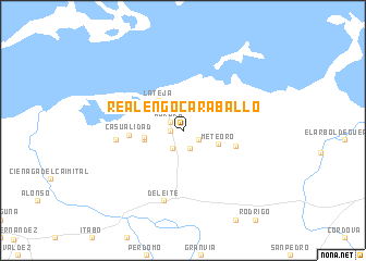
Realengo Caraballo (Matanzas, Cuba)Realengo Caraballo is a town in the Matanzas region of Cuba. An overview map of the region around Realengo Caraballo is displayed below.
regional and 3d topo map of Realengo Caraballo, Cuba ::
Realengo Caraballo airports ::
The nearest airport is VRA - Varadero Juan Gualberto Gomez Intl, located 68.7 km west of Realengo Caraballo.
Other airports nearby include SNU - Santa Clara Abel Santamaria (104.5 km south east), CFG - Cienfuegos Jaime Gonzalez (105.9 km south), HAV - Havana Jose Marti Intl (168.6 km west), CYO - Cayo Vilo Acuna Intl (177.8 km south west), Nearby towns ::
Aurora (1.1km west) //
Aurora (1.5km north west) //
Meteoro (1.7km south east) //
Valdivieso (2.1km south west) //
Caña de Castilla (2.1km south) //
Meteoro (3.6km south east) //
La Teja (3.8km north west) //
Balnearios Menéndez (3.7km west) //
Conconí (3.7km west) //
Playa Menéndez (4.7km north west) //
Casualidad (5.1km west) //
Santa Mónica (5.3km east) //
Casualidad (6.4km west) //
Deleite (7.5km south) //
[all distances 'as the bird flies' and approximate] 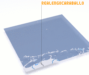 Places with similar names to Realengo Caraballo, Cuba :: Disclaimer :: Information on this page comes without warranty of any kind |
||
|
Where is Realengo Caraballo? Elevation and coordinates ::
Latitude (lat): 23°2'55"N Longitude (lon): 80°45'56"W
Elevation (approx.): 12m (map arrows pan, magnifying glasses zoom) |
||
|
Visiting Realengo Caraballo? Hotel/Accommodation ::
Book a hotel in Realengo Caraballo Travel Guide ::
Buy a travel guide for Cuba rental cars ::
car rental offers GPS waypoint ::
download a GPX waypoint (PoI) of Realengo Caraballo for your GPS receiver
|
||