|
search place name
|
||
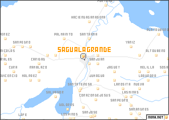
Sagua la Grande (Villa Clara, Cuba)Sagua la Grande is a town in the Villa Clara region of Cuba. An overview map of the region around Sagua la Grande is displayed below.
regional and 3d topo map of Sagua la Grande, Cuba ::
Sagua la Grande airports ::
The nearest airport is SNU - Santa Clara Abel Santamaria, located 37.4 km south of Sagua la Grande.
Other airports nearby include CFG - Cienfuegos Jaime Gonzalez (80.6 km south west), VRA - Varadero Juan Gualberto Gomez Intl (141.7 km west), AVI - Ciego De Avila Maximo Gomez (158.1 km south east), CYO - Cayo Vilo Acuna Intl (200.9 km south west), Nearby towns ::
Resulta (1.2km south east) //
San Juan (2.7km east) //
Hermanos Toledo (2.8km north east) //
Santa Ana (4.9km north) //
Jumagua (5.2km south east) //
Santa Teresa (6.4km south) //
Jumagua (6.0km west) //
Miguel de Sol (6.4km north west) //
Palmarito (6.4km north west) //
Crucero Carolina (6.8km south east) //
Sitiecito (6.9km south) //
Jagüey (6.6km south east) //
Carolina (7.5km south east) //
Chinchila (7.7km west) //
Hacienda Ganadera (8.6km north) //
Corazón de Jesús (9.1km south) //
Salvador (10.1km south west) //
La Rosita (10.0km south east) //
[all distances 'as the bird flies' and approximate] 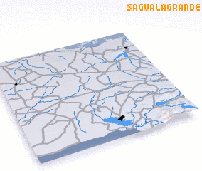 Places with similar names to Sagua la Grande, Cuba :: Disclaimer :: Information on this page comes without warranty of any kind |
||
|
Where is Sagua la Grande? Elevation and coordinates ::
Latitude (lat): 22°48'24"N Longitude (lon): 80°4'32"W
Elevation (approx.): 16m (map arrows pan, magnifying glasses zoom) |
||
|
Visiting Sagua la Grande? Hotel/Accommodation ::
Book a hotel in Sagua la Grande Travel Guide ::
Buy a travel guide for Cuba rental cars ::
car rental offers GPS waypoint ::
download a GPX waypoint (PoI) of Sagua la Grande for your GPS receiver
|
||