|
search place name
|
||
Santa Isabel (Santiago de Cuba, Cuba)Santa Isabel is a town in the Santiago de Cuba region of Cuba. An overview map of the region around Santa Isabel is displayed below.
regional and 3d topo map of Santa Isabel, Cuba ::

Santa Isabel airports ::
The nearest airport is GAO - Guantanamo Mariana Grajales, located 34.0 km east of Santa Isabel.
Other airports nearby include SCU - Santiago De Cuba Antonio Maceo Intl (38.9 km west), MOA - Moa Orestes Acosta (86.1 km north east), BCA - Baracoa Playa Gustavo Rizo (106.8 km east), HOG - Holguin Frank Pais Intl (116.5 km north west), Nearby towns ::
El Aguacate (0.3km north west) //
Lepoir (1.2km south east) //
Perico (2.5km south east) //
La Sidonia (2.6km south west) //
Santa Emilia (3.0km south) //
Tres Brazos (3.4km south east) //
Navelo (3.5km north west) //
Bravo (4.0km south) //
Ofelia (3.9km north west) //
Retiro (4.0km north west) //
Macá Arriba (4.2km south east) //
Mon Repos (4.4km south) //
La Juba (4.5km west) //
La Tontina (4.8km south) //
La Josefina (4.9km south) //
Esperanza (5.0km west) //
Deseada (5.2km west) //
Arroyo Negro (5.2km east) //
Ramón de las Yaguas (5.8km south) //
Yerba de Guinea (5.7km west) //
El Ramón (6.0km south west) //
Sitio Cabaña (5.8km north east) //
Cabañas (6.1km north east) //
Ramón Conde (7.1km east) //
Casimba (7.6km south east) //
La Perla (7.7km north) //
Bárbara (7.6km south west) //
Santa Isabel (8.2km north west) //
Palma Mocha (8.3km east) //
[all distances 'as the bird flies' and approximate] 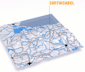 Places with similar names to Santa Isabel, Cuba ::
// Santa Isabel (BR)
// Santa Isabel (BR)
// Santa Isabel (BR)
// Santa Isabel (BR)
// Santa Isabel (BR)
// Santa Isabel (BR)
// Santa Isabel (BR)
// Santa Isabel (BR)
// Santa Isabel (BR)
// Santa Isabel (BR)
Disclaimer :: Information on this page comes without warranty of any kind |
||
|
Where is Santa Isabel? Elevation and coordinates ::
Latitude (lat): 20°5'0"N Longitude (lon): 75°29'0"W
Elevation (approx.): 227m (map arrows pan, magnifying glasses zoom) |
||
|
Visiting Santa Isabel? Hotel/Accommodation ::
Book a hotel in Santa Isabel Travel Guide ::
Buy a travel guide for Cuba rental cars ::
car rental offers GPS waypoint ::
download a GPX waypoint (PoI) of Santa Isabel for your GPS receiver
|
||