|
search place name
|
||
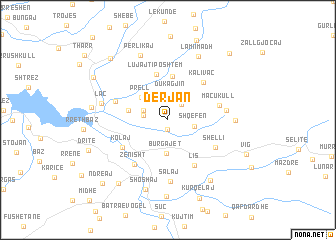
Derjan (Dibër, Albania)Derjan is a town in the Dibër region of Albania. An overview map of the region around Derjan is displayed below.
regional and 3d topo map of Derjan, Albania ::
Derjan airports ::
The nearest airport is TIA - Tirana Rinas, located 40.3 km south west of Derjan.
Other airports nearby include OHD - Ohrid (79.2 km south east), TGD - Podgorica (101.3 km north west), PRN - Pristina (128.5 km north east), SKP - Skopje (133.7 km east), Nearby towns ::
Barbullej (1.0km south) //
Urxallë (2.1km north east) //
Rremull (2.1km west) //
Dukagjin (2.9km north) //
Zmaç (2.3km north west) //
Shqefën (2.3km east) //
Burgajet (3.7km south) //
Prell (3.3km north west) //
Rukaj (3.4km west) //
Gjoçaj (4.9km north) //
Lujajt i Poshtëm (5.2km north) //
Kalivaç (5.1km north east) //
Kolaj (4.9km south west) //
Lis (5.6km south east) //
Macukull (4.6km east) //
Shëlli (5.0km south east) //
Zenisht (5.7km south west) //
Bruç (4.9km north west) //
Deje Macukull (5.0km east) //
Salaj (6.9km south) //
Dazhjan (5.6km east) //
Laç (5.9km west) //
Perlikaj (7.6km north) //
Lami i Madh (7.5km north) //
Shoshaj (8.0km south) //
Gjalish (7.6km south east) //
Mallunxë (8.6km south) //
Urakë (6.5km west) //
Burrel (8.2km south west) //
[all distances 'as the bird flies' and approximate]  Places with similar names to Derjan, Albania ::
Disclaimer :: Information on this page comes without warranty of any kind |
||
|
Where is Derjan? Elevation and coordinates ::
Latitude (lat): 41°40'25"N Longitude (lon): 20°3'30"E
Elevation (approx.): 479m (map arrows pan, magnifying glasses zoom) |
||
|
Visiting Derjan? Hotel/Accommodation ::
Book a hotel in Derjan Travel Guide ::
Buy a travel guide for Albania rental cars ::
car rental offers GPS waypoint ::
download a GPX waypoint (PoI) of Derjan for your GPS receiver
|
||