|
search place name
|
||
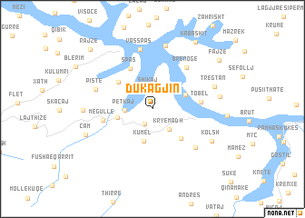
Dukagjin (Kukës, Albania)Dukagjin is a town in the Kukës region of Albania. An overview map of the region around Dukagjin is displayed below.
regional and 3d topo map of Dukagjin, Albania ::
Dukagjin airports ::
The nearest airport is PRN - Pristina, located 80.7 km north east of Dukagjin.
Other airports nearby include TGD - Podgorica (88.9 km west), TIA - Tirana Rinas (90.4 km south west), OHD - Ohrid (110.7 km south), SKP - Skopje (112.6 km east), Nearby towns ::
Shtanë (1.9km south) //
Shikaj (2.5km north) //
Kryemadh (3.0km south east) //
Petkaj (2.5km west) //
Begaj (3.3km north east) //
Kumel (4.1km south) //
Shënmëri (3.3km west) //
Metaliaj (3.5km north east) //
Kalimash (4.4km south east) //
Sakanjan (4.5km north west) //
Spas (5.3km north) //
Tobël (4.5km east) //
Mëgullë (4.7km west) //
Brenogë (5.9km north east) //
Fusha e Dukagjinit (6.1km south east) //
Pistë (5.7km north west) //
(( Vas-Spas )) (7.4km north) //
Liqeni i Kuq (7.8km north) //
Tregtan (6.3km north east) //
Kolsh (6.7km south east) //
Munekë (6.4km east) //
Gëdheshtë (6.4km west) //
Cam (6.9km south west) //
Kabashit (9.1km north east) //
Fajzë (8.5km north east) //
Rajzë (9.3km north west) //
[all distances 'as the bird flies' and approximate] 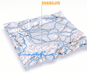 Places with similar names to Dukagjin, Albania ::
// Dukagjin (AL)
Disclaimer :: Information on this page comes without warranty of any kind |
||
|
Where is Dukagjin? Elevation and coordinates ::
Latitude (lat): 42°6'49"N Longitude (lon): 20°16'36"E
Elevation (approx.): 544m (map arrows pan, magnifying glasses zoom) |
||
|
Visiting Dukagjin? Hotel/Accommodation ::
Book a hotel in Dukagjin Travel Guide ::
Buy a travel guide for Albania rental cars ::
car rental offers GPS waypoint ::
download a GPX waypoint (PoI) of Dukagjin for your GPS receiver
|
||