|
search place name
|
||
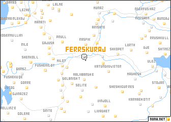
Ferr -Skuraj (Lezhë, Albania)Ferr -Skuraj is a town in the Lezhë region of Albania. An overview map of the region around Ferr -Skuraj is displayed below.
regional and 3d topo map of Ferr -Skuraj, Albania ::
Ferr -Skuraj airports ::
The nearest airport is TIA - Tirana Rinas, located 31.1 km south of Ferr -Skuraj.
Other airports nearby include TGD - Podgorica (85.2 km north west), OHD - Ohrid (99.8 km south east), TIV - Tivat (116.8 km north west), PRN - Pristina (143.7 km north east), Nearby towns ::
Rasfik (3.6km north) //
Bërzanë (3.2km north west) //
Ferr-Shkopet (2.9km east) //
Skuraj (2.9km east) //
Mali i Bardhë (4.1km south) //
Mal-Milot (3.4km south west) //
Fangu (4.4km north east) //
Milot (3.9km west) //
Katundi i Vjetër (4.4km south east) //
Delbnisht (5.4km south west) //
(( Ndërshegas )) (4.8km south west) //
Fierzë (5.8km north) //
Gallatë (6.0km south) //
Selitë (6.4km south) //
Prull (5.7km north west) //
Pllanë (5.3km west) //
(( Arishtë )) (6.8km north) //
Shkopet (5.5km east) //
Shullaz (6.1km south west) //
Gurrë (6.5km south west) //
Lesterë (7.9km south) //
Zejmen (6.2km west) //
Laç (7.6km south west) //
Gajush (6.6km north west) //
(( Bulshizë )) (8.4km north) //
Fushë-Milot (6.8km west) //
Fushë-Milot (6.9km west) //
Fushë-Milot (6.9km west) //
Fushë-Milot (6.9km west) //
[all distances 'as the bird flies' and approximate]  Places with similar names to Ferr -Skuraj, Albania :: Disclaimer :: Information on this page comes without warranty of any kind |
||
|
Where is Ferr -Skuraj? Elevation and coordinates ::
Latitude (lat): 41°41'35"N Longitude (lon): 19°45'41"E
Elevation (approx.): 101m (map arrows pan, magnifying glasses zoom) |
||
|
Visiting Ferr -Skuraj? Hotel/Accommodation ::
Book a hotel in Ferr -Skuraj Travel Guide ::
Buy a travel guide for Albania rental cars ::
car rental offers GPS waypoint ::
download a GPX waypoint (PoI) of Ferr -Skuraj for your GPS receiver
|
||