|
search place name
|
||
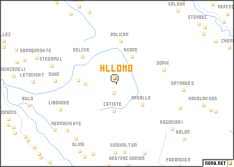
Hllomo (Gjirokastër, Albania)Hllomo is a town in the Gjirokastër region of Albania. An overview map of the region around Hllomo is displayed below.
regional and 3d topo map of Hllomo, Albania ::
Hllomo airports ::
The nearest airport is IOA - Ioannina, located 58.1 km south east of Hllomo.
Other airports nearby include CFU - Kerkyra/corfu Ioannis Kapodistrias Intl (63.7 km south west), KSO - Kastoria Aristotelis (90.1 km north east), OHD - Ohrid (127.9 km north), KZI - Kozani Filippos (129.7 km east), Nearby towns ::
Mavrojer (1.5km south) //
Çatistë (4.4km south) //
Skore (4.6km north east) //
Labova e Sipërme (3.9km west) //
Apsallë (4.6km south east) //
Labova e Poshtme (4.8km west) //
Poliçan (6.8km north) //
Selckë (6.0km north west) //
Sopik (6.1km east) //
Nepravishtë (9.7km south west) //
Vllahogoranxi (10.2km south west) //
Pogonianí (10.0km south east) //
[all distances 'as the bird flies' and approximate]  Places with similar names to Hllomo, Albania ::
Disclaimer :: Information on this page comes without warranty of any kind |
||
|
Where is Hllomo? Elevation and coordinates ::
Latitude (lat): 40°4'8"N Longitude (lon): 20°20'42"E
Elevation (approx.): 809m (map arrows pan, magnifying glasses zoom) |
||
|
Visiting Hllomo? Hotel/Accommodation ::
Book a hotel in Hllomo Travel Guide ::
Buy a travel guide for Albania rental cars ::
car rental offers GPS waypoint ::
download a GPX waypoint (PoI) of Hllomo for your GPS receiver
|
||