|
search place name
|
||
Karma e Hotit (Dibër, Albania)Karma e Hotit is a town in the Dibër region of Albania. An overview map of the region around Karma e Hotit is displayed below.
regional and 3d topo map of Karma e Hotit, Albania ::

Karma e Hotit airports ::
The nearest airport is TIA - Tirana Rinas, located 24.7 km south west of Karma e Hotit.
Other airports nearby include OHD - Ohrid (87.1 km south east), TGD - Podgorica (98.0 km north west), TIV - Tivat (129.8 km north west), PRN - Pristina (144.3 km north east), Nearby towns ::
Fushë-Pjeshkë (2.3km north) //
Gjergas (2.1km east) //
Lunre (3.0km north) //
Sheshi i Gurrës (4.0km north west) //
Kroi i Lajthis (3.7km north east) //
Stojan (4.8km north east) //
Madhesh (5.6km north) //
Gërnac (4.8km south west) //
Fushetanë (5.8km south east) //
Baz (5.7km north east) //
Shkretë (7.1km south west) //
Vinjoll (5.7km west) //
Kokërdhok (7.8km north) //
Cakarac (8.3km south) //
Karicë (6.4km east) //
Bushkash (7.7km north east) //
Livadhet (6.6km south west) //
Blat (7.4km north east) //
Ulëz (8.6km north) //
Selitë (8.0km south east) //
Mafsheq (7.9km south west) //
Nojë (9.3km south west) //
Katundi i Vjetër (8.9km north west) //
Përcall (9.5km south east) //
[all distances 'as the bird flies' and approximate] 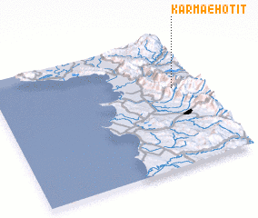 Places with similar names to Karma e Hotit, Albania :: Disclaimer :: Information on this page comes without warranty of any kind |
||
|
Where is Karma e Hotit? Elevation and coordinates ::
Latitude (lat): 41°36'26"N Longitude (lon): 19°52'8"E
Elevation (approx.): 402m (map arrows pan, magnifying glasses zoom) |
||
|
Visiting Karma e Hotit? Hotel/Accommodation ::
Book a hotel in Karma e Hotit Travel Guide ::
Buy a travel guide for Albania rental cars ::
car rental offers GPS waypoint ::
download a GPX waypoint (PoI) of Karma e Hotit for your GPS receiver
|
||