|
search place name
|
||
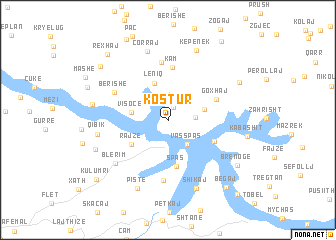
Kostur (Kukës, Albania)Kostur is a town in the Kukës region of Albania. An overview map of the region around Kostur is displayed below.
regional and 3d topo map of Kostur, Albania ::
Kostur airports ::
The nearest airport is PRN - Pristina, located 77.0 km north east of Kostur.
Other airports nearby include TGD - Podgorica (83.7 km west), TIA - Tirana Rinas (97.9 km south west), SKP - Skopje (117.0 km east), OHD - Ohrid (121.0 km south), Nearby towns ::
(( Rushtë-Shëngjergj )) (1.5km north) //
Çalaj (2.6km north east) //
(( Ishefaj )) (2.2km east) //
(( Vas-Spas )) (3.1km south east) //
Helshan (3.2km north east) //
Visoçë (3.2km west) //
Leniq (4.3km north) //
Rajzë (4.0km south west) //
Spas (5.1km south) //
Liqeni i Kuq (4.5km south east) //
Goxhaj (4.5km north east) //
Kam (5.9km north) //
Lagjja e Sipërme (6.5km north) //
Sakanjan (6.7km south) //
Berishë (5.5km north west) //
Blerim (6.5km south west) //
Çorraj (7.8km north) //
Qibik (6.0km west) //
Shikaj (7.9km south) //
Pistë (8.0km south) //
Kepenek (8.1km north) //
Shëngjergj (6.5km west) //
Truen (6.8km south west) //
Muçaj (7.2km north east) //
Kabashit (6.8km east) //
Brenogë (7.6km south east) //
Gjonpapaj (8.2km north west) //
Begaj (8.9km south east) //
Rexhaj (8.9km north west) //
[all distances 'as the bird flies' and approximate] 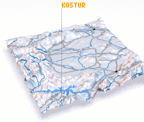 Places with similar names to Kostur, Albania ::
Disclaimer :: Information on this page comes without warranty of any kind |
||
|
Where is Kostur? Elevation and coordinates ::
Latitude (lat): 42°12'14"N Longitude (lon): 20°14'41"E
Elevation (approx.): 566m (map arrows pan, magnifying glasses zoom) |
||
|
Visiting Kostur? Hotel/Accommodation ::
Book a hotel in Kostur Travel Guide ::
Buy a travel guide for Albania rental cars ::
car rental offers GPS waypoint ::
download a GPX waypoint (PoI) of Kostur for your GPS receiver
|
||