|
search place name
|
||
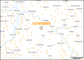
Kutërqarë (Elbasan, Albania)Kutërqarë is a town in the Elbasan region of Albania. An overview map of the region around Kutërqarë is displayed below.
regional and 3d topo map of Kutërqarë, Albania ::
Kutërqarë airports ::
The nearest airport is OHD - Ohrid, located 62.0 km north east of Kutërqarë.
Other airports nearby include TIA - Tirana Rinas (63.5 km north west), KSO - Kastoria Aristotelis (113.3 km south east), CFU - Kerkyra/corfu Ioannis Kapodistrias Intl (146.7 km south), IOA - Ioannina (149.0 km south east), Nearby towns ::
Dushk (2.5km north east) //
Mazrekë (3.0km north west) //
Sult (3.5km south) //
Cingar (3.4km north east) //
(( Darzezë )) (3.8km north) //
(( Shtrazë )) (3.5km north east) //
Kukucovë (4.4km south) //
Zgjupë (3.6km south east) //
Drizë (3.6km east) //
Dragot-Sulovë (3.8km west) //
(( Porrepth )) (4.2km north west) //
Shushica e Vogël (5.1km north) //
Dufshan (4.9km south east) //
Mhallë (4.3km south west) //
Irmanj (5.9km south) //
Goricë (4.6km west) //
Zgjupë-Kodër (5.0km east) //
Cërujë (4.9km east) //
Banjë (6.2km north west) //
Kaçivel (6.0km north east) //
Vilëz (5.1km west) //
Gjergjovinë (5.1km east) //
Qafë (5.6km north west) //
Shënavlash (7.0km north) //
Topojan (5.5km south west) //
Cingari i Sipërm (5.9km north east) //
Përrenjas (7.1km south) //
Shkëmb (5.9km west) //
Sheshi i Zi (7.8km south) //
[all distances 'as the bird flies' and approximate]  Places with similar names to Kutërqarë, Albania ::
// Kottārakara (IN)
// Qādirgarh (IN)
Disclaimer :: Information on this page comes without warranty of any kind |
||
|
Where is Kutërqarë? Elevation and coordinates ::
Latitude (lat): 40°54'58"N Longitude (lon): 20°5'31"E
Elevation (approx.): 364m (map arrows pan, magnifying glasses zoom) |
||
|
Visiting Kutërqarë? Hotel/Accommodation ::
Book a hotel in Kutërqarë Travel Guide ::
Buy a travel guide for Albania rental cars ::
car rental offers GPS waypoint ::
download a GPX waypoint (PoI) of Kutërqarë for your GPS receiver
|
||