|
search place name
|
||
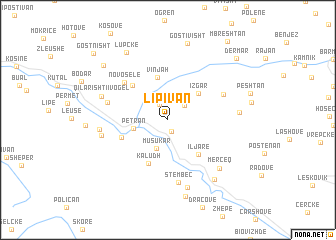
Lipivan (Gjirokastër, Albania)Lipivan is a town in the Gjirokastër region of Albania. An overview map of the region around Lipivan is displayed below.
regional and 3d topo map of Lipivan, Albania ::
Lipivan airports ::
The nearest airport is IOA - Ioannina, located 65.9 km south east of Lipivan.
Other airports nearby include KSO - Kastoria Aristotelis (74.9 km east), CFU - Kerkyra/corfu Ioannis Kapodistrias Intl (82.5 km south west), OHD - Ohrid (109.6 km north), KZI - Kozani Filippos (118.4 km east), Nearby towns ::
Trebozisht (1.3km south) //
Ogdunan (1.9km north) //
Delvinë (2.2km north east) //
(( Musukar )) (3.3km south) //
Petran (3.0km west) //
(( Izgar )) (3.9km north east) //
(( Vinjah )) (4.8km north) //
Iljarë (4.6km south east) //
Kaludh (5.1km south) //
Benjë-Novoselë (4.9km north west) //
Gjinkar (4.4km south west) //
(( Novoselë )) (5.6km north west) //
Kovaçisht (5.5km north east) //
Qilarisht (5.5km west) //
Stëmbec (7.0km south) //
Badëlonjë (6.0km west) //
Lagjja e Re (5.9km west) //
Qilarishti i Vogël (6.2km north west) //
Pëllumbar (7.8km south) //
(( Mercëq )) (7.0km south east) //
Gjirakarë (6.1km east) //
Iljarë (7.7km south east) //
Kanikol (8.7km south) //
Gostivisht (8.7km north) //
Lupckë (8.3km north west) //
Tremisht (8.2km north west) //
Dërmar (9.0km north east) //
Mbreshtan (10.1km north east) //
Gostnisht (9.8km north west) //
[all distances 'as the bird flies' and approximate] 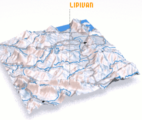 Places with similar names to Lipivan, Albania ::
Disclaimer :: Information on this page comes without warranty of any kind |
||
|
Where is Lipivan? Elevation and coordinates ::
Latitude (lat): 40°13'3"N Longitude (lon): 20°27'9"E
Elevation (approx.): 772m (map arrows pan, magnifying glasses zoom) |
||
|
Visiting Lipivan? Hotel/Accommodation ::
Book a hotel in Lipivan Travel Guide ::
Buy a travel guide for Albania rental cars ::
car rental offers GPS waypoint ::
download a GPX waypoint (PoI) of Lipivan for your GPS receiver
|
||